Blixterboda
| Blixterboda | |
| Tidigare småort | |
| Land | |
|---|---|
| Landskap | Västmanland |
| Län | Örebro län |
| Kommun | Lindesbergs kommun |
| Distrikt | Fellingsbro distrikt |
| Koordinater | 59°29′18″N 15°26′14″Ö / 59.48833°N 15.43722°Ö |
| Area | 15 hektar (2000) |
| Folkmängd | 51 (2000) |
| Befolkningstäthet | 3,4 inv./hektar |
| Tidszon | CET (UTC+1) |
| - sommartid | CEST (UTC+2) |
| Småortskod | S6017 |
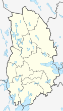
Blixterbodas läge i Örebro län | |
Blixterboda är en ort i Fellingsbro socken i Lindesbergs kommun, Örebro län. Den klassades som småort till och med år 2000.
Noter
| ||||||||||||||||
Media som används på denna webbplats
Författare/Upphovsman: Erik Frohne, Licens: CC BY 3.0
Location map of Örebro County in Sweden
Equirectangular projection, N/S stretching 196 %. Geographic limits of the map:
- N: 60.20° N
- S: 58.60° N
- W: 14.10° E
- E: 15.90° E
Shiny red button/marker widget. Used to mark the location of something such as a tourist attraction.


