Paintsville
| Paintsville | |
 Paintsville City Hall | |
| Land | |
|---|---|
| Delstat | Kentucky |
| County | Johnson County |
| Höjdläge | 187 m ö.h. |
| Koordinater | 37°48′52″N 82°48′26″V / 37.81444°N 82.80722°V |
| Yta | 130,6 km² |
| Folkmängd | 3 459 (2010) |
| Befolkningstäthet | 26 invånare/km² |
| Grundad | 1826 under namnet Paint Lick Station, stadsrättigheter 1834 |
| ZIP-kod | 41240 |
| Geonames | 4303543 |
 Ortens läge i Kentucky | |
 Kentuckys läge i USA | |
| Webbplats: www.cityofpaintsville.net/ | |
Paintsville är en småstad i östra Kentucky.
Paintsville, som är huvudort i Johnson County, hade 2010 omkring 3.500 invånare. Staden ligger i dalgången vid sammanflödet av Paint Creek och Levisa Fork med Big Sandy River i Appalachernas kolgruveområden, nära gränsen till West Virginia.
Museer och byggnadsminnen
U.S. 23 Country Music Highway Museum, som öppnades 2005, behandlar countrymusikartister som är födda eller har levt längs U.S. Route 23 i östra Kentucky, bland andra Billy Ray Cyrus, The Judds, Tom T. Hall, Loretta Lynn, Rebecca Lynn Howard, Keith Whitley, Dwight Yoakam och Patty Loveless.[1]
Mayo Mansion på 405 Third Street uppfördes för kolgruvemiljonären John C. C. Mayo (1864-1914) mellan 1905 och 1912. Det är idag ett byggnadsminne och används som Our Lady of the Mountains School.
Mayo Memorial United Methodist Church på Third Street är finansierad av John C. C. Mayo och uppförd av italienska murare. Den invigdes 1909 och upptogs i National Register of Historic Places 1989.
Bildgalleri
 Hörnet Court Street/Main Street
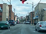 Affärsgata
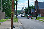 Main Street
 Mayo Memorial United Methodist Church
 Public Library
 Patterson House
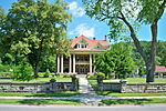 Mayo Mansion
 US 23 Country Music Highway Museum
Personer från Paintsville
Källor
- Denna artikel är baserad på artikeln Paintsville, Kentucky på engelskspråkiga Wikipedia.
Noter
- ^ Visit Paintvilles webbplats Arkiverad 30 april 2015 hämtat från the Wayback Machine., läst 2015-03-23
Externa länkar
Media som används på denna webbplats


Shiny red button/marker widget. Used to mark the location of something such as a tourist attraction.
Författare/Upphovsman: This version: uploader
Base versions this one is derived from: originally created by en:User:Wapcaplet, Licens: CC BY 2.0
Map of USA with Kentucky highlighted


Front and eastern end of the former Paintsville Public Library, located on the northwestern corner of the junction of Second and College Streets in Paintsville, Kentucky, United States. Built in 1934, it is listed on the National Register of Historic Places.

Författare/Upphovsman: J654567, Licens: CC BY-SA 3.0
View of Main Street in Paintsville, Kentucky.

Författare/Upphovsman: J654567, Licens: CC BY-SA 3.0
Mayo Memorial United Methodist Church in Paintsville, Kentucky.
.jpg)
Författare/Upphovsman: J654567, Licens: CC BY-SA 3.0
Mayo Mansion in Paintsville, Kentucky.
Front and northern end of the Paintsville City Hall, located at the junction of Euclid Avenue (Kentucky Route 40) with Second and Margaret Heights streets in Paintsville, Kentucky, United States. Built in 1939, it is listed on the National Register of Historic Places.

Författare/Upphovsman: J654567, Licens: CC BY-SA 3.0
U.S. 23 Country Music Highway Museum in Paintsville, Kentucky.

Författare/Upphovsman: J654567, Licens: CC BY-SA 3.0
Paintsville's Main Street decorated for Christmas.

Looking east on Main Street toward the Court Street intersection in downtown Paintsville, Kentucky, United States.

Southern side and front of the Patterson House, located on the northwestern corner of the junction of Second and West Streets in Paintsville, Kentucky, United States. Built in 1907, it is listed on the National Register of Historic Places.
Författare/Upphovsman: Alexrk2, Licens: CC BY 3.0
Den här Det karta skapades med GeoTools.