Covington, Kentucky
| Covington | |
| Stad (city) | |
| Land | |
|---|---|
| Delstat | |
| County | Kenton County |
| Höjdläge | 155 m ö.h. |
| Koordinater | 39°3′54″N 84°30′35″V / 39.06500°N 84.50972°V |
| Area | 35,67 km² (2010)[3] |
| Folkmängd | 40 961 (2020)[4] |
| Befolkningstäthet | 1 148 invånare/km² |
| Grundad | 1815[1] |
| Borgmästare | Ron Washington (2024–)[2] |
| Tidszon | EST (UTC-5) |
| - sommartid | EDT (UTC-4) |
| Riktnummer | 859 |
| GNIS-kod | 490167 |
| Geonames | 4288809 |
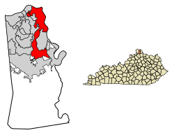
Översiktskarta | |
Kentuckys läge i USA | |
| Wikimedia Commons: Covington, Kentucky | |
| Webbplats: https://www.covingtonky.gov/ | |
| Redigera Wikidata | |
Covington är en stad och en av två huvudorter (county seat) i Kenton County i delstaten Kentucky, USA. Staden har 40 961 invånare (2020), på en yta av 35,67 km².
Källor
- ^ hämtat från: franskspråkiga Wikipedia.[källa från Wikidata]
- ^ läs online, www.covingtonky.gov , läst: 9 februari 2025.[källa från Wikidata]
- ^ United States Census Bureau, 2010 U.S. Gazetteer Files, United States Census Bureau, 2010, läst: 9 juli 2020.[källa från Wikidata]
- ^ United States Census Bureau (red.), USA:s folkräkning 2020, läs online, läst: 1 januari 2022.[källa från Wikidata]
Externa länkar
 Wikimedia Commons har media som rör Covington.
|
Media som används på denna webbplats
Författare/Upphovsman: This version: uploader
Base versions this one is derived from: originally created by en:User:Wapcaplet, Licens: CC BY 2.0
Map of USA with Kentucky highlighted
Författare/Upphovsman: EEJCC, Licens: CC BY-SA 4.0
Covington skyline viewed from Devou Park with the Ohio River on the left.
(c) DemocraticLuntz på engelska Wikipedia, CC BY-SA 4.0
Location of Covington in Kenton County, Kentucky.
FIPS code: 21-17848
Own work, based on concept by Arkyan, using Census Bureau Tiger GIS data and a custom fork of Kartography adapted for this purpose, available at


