Yttre Gällareböke
| Yttre Gällareböke | |
| Tidigare småort | |
| Land | |
|---|---|
| Landskap | Småland |
| Län | Kronobergs län |
| Kommun | Markaryds kommun |
| Koordinater | 56°30′1″N 13°35′11″Ö / 56.50028°N 13.58639°Ö |
| Area | 19 hektar (2000) |
| Folkmängd | 53 (2000) |
| Befolkningstäthet | 2,79 inv./hektar |
| Tidszon | CET (UTC+1) |
| - sommartid | CEST (UTC+2) |
| Småortskod | S1971 |
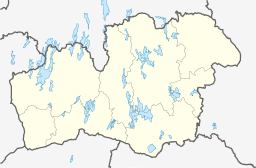
Yttre Gällarebökes läge i Kronobergs län. | |
| Befolknings- och arealfakta från SCB | |
Yttre Gällareböke är ett mindre samhälle i Markaryds socken i Markaryds kommun, Kronobergs län i sydvästra Småland. År 1995 och 2000 klassades Yttre Gällareböke som småort av SCB.
Media som används på denna webbplats
Shiny red button/marker widget. Used to mark the location of something such as a tourist attraction.
Författare/Upphovsman: Erik Frohne, Licens: CC BY 3.0
Location map of Kronoberg County in Sweden. N-S stretching is 183%, geographic limits of the map:
- N: 57.30° N
- S: 56.30° N
- W: 13.20° E
- E: 16.00° E


