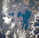
Yellowstonesjön
| Den här artikeln behöver källhänvisningar för att kunna verifieras. (2023-10) Åtgärda genom att lägga till pålitliga källor (gärna som fotnoter). Uppgifter utan källhänvisning kan ifrågasättas och tas bort utan att det behöver diskuteras på diskussionssidan. |
| Tillflöde | Yellowstonefloden | |
|---|---|---|
| Utflöde | Yellowstonefloden | |
| Flodbäcken | Yellowstone River basin | |
| Land för flodbäckenet | USA | |
| Land | USA | |
| Inom det administrativa området | • Wyoming • Teton County | |
| Koordinater | 44°28′0″N 110°22′0″W | |
| Höjd över havet | 2 357 meter | |
| Längd | 32 kilometer | |
| Bredd | 23 kilometer | |
| Djup | 117 meter | |
| Area | 354 kvadratkilometer | |
| Omkrets | 177 kilometer | |
| Ligger i skyddat område | Yellowstone nationalpark | |
Yellowstonesjön, engelska Yellowstone Lake, är en sjö i Yellowstone nationalpark, Wyoming, USA. Den ligger 2357 meter över havsnivå och rinner ut i Yellowstonefloden.
Media som används på denna webbplats
Författare/Upphovsman: Tkgd2007, Licens: CC BY-SA 3.0
A new incarnation of Image:Question_book-3.svg, which was uploaded by user AzaToth. This file is available on the English version of Wikipedia under the filename en:Image:Question book-new.svg
Icon of simple gray pencil. An icon for Russian Wikipedia RFAR page.
Yellowstone National Park, the largest national park in the United States, and Yellowstone Lake, the largest high-mountain lake in North America [139 square miles (360 square kilometers)], are featured in this west-southwest-looking, low-oblique photograph. The park lies atop a massive, dish-shaped, volcanic caldera approximately 30 miles (48 kilometers) by 45 miles (72 kilometers) in size. The caldera was partially filled by lava that flowed from the cracks and opening floor after the massive eruption and collapse of the volcano approximately 600 000 years ago—an eruption 1000 times the force of the 1980 eruption of Mount Saint Helens Volcano in Washington. With approximately 10 000 geysers and hot springs, Yellowstone sits on one of the hottest "hot spots" on Earth. Between 1923 and 1985, the caldera rose almost 4 feet (1 meter) in height. Since 1985, the caldera has sunk approximately 6 inches (15 centimeters). Visible are portions of the volcanic Absaroka Range to the east and three smaller lakes near Yellowstone Lake—Shoshone, to the southwest; Lewis, southeast of Shoshone; and Heart Lake, the smallest and most southeastern.


