Y Gaer
| Y Gaer | |
| Befästning | |
 | |
| Land | |
|---|---|
| Riksdel | Wales |
| Kommun | Powys |
| Community | Yscir |
| Koordinater | 51°57′23″N 3°27′06″V / 51.9564°N 3.4516°V |
| Tidszon | UTC (UTC+0) |
| - sommartid | BST (UTC+1) |
 Läge i Storbritannien | |
Y Gaer är en lämning av en romersk befästning (castrum) i Wales.[1] Den ligger i kommunen Powys.
Galleri
 Lämningar av norra vallen
 Östra porten
 Södra porten
 Västra porten
Källor
- ^ ”Brecon Roman Fort (Cicucium or Y Gaer)”. Roman Britain. http://www.roman-britain.co.uk/places/brecon-roman-fort/. Läst 11 juli 2022.
Media som används på denna webbplats
.svg)
United Kingdom relief location map.jpg
Författare/Upphovsman: Alexrk2, Licens: CC BY-SA 3.0
Location map of the United Kingdom
Författare/Upphovsman: Alexrk2, Licens: CC BY-SA 3.0
Location map of the United Kingdom

Red pog.svg
Shiny red button/marker widget. Used to mark the location of something such as a tourist attraction.
Shiny red button/marker widget. Used to mark the location of something such as a tourist attraction.

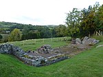
Y Gaer Brecon HenSne 04 east gate.JPG
Författare/Upphovsman: PicturePrince, Licens: CC BY-SA 4.0
Y Gaer (ancient Roman fort) near Brecon, Powys, Wales: foundations of the east gate
Författare/Upphovsman: PicturePrince, Licens: CC BY-SA 4.0
Y Gaer (ancient Roman fort) near Brecon, Powys, Wales: foundations of the east gate

Y Gaer Brecon - North Wall.JPG
Författare/Upphovsman: ViennaUK, Licens: CC BY-SA 4.0
Y Gaer (ancient Roman fort) near Brecon, Powys, Wales: north wall
Författare/Upphovsman: ViennaUK, Licens: CC BY-SA 4.0
Y Gaer (ancient Roman fort) near Brecon, Powys, Wales: north wall

Y Gaer Brecon HenSne 16 corner turret.JPG
Författare/Upphovsman: PicturePrince, Licens: CC BY-SA 4.0
Y Gaer (ancient Roman fort) near Brecon, Powys, Wales: foundations of the north east corner turret
Författare/Upphovsman: PicturePrince, Licens: CC BY-SA 4.0
Y Gaer (ancient Roman fort) near Brecon, Powys, Wales: foundations of the north east corner turret

Y Gaer Brecon HenSne 06 south gate.JPG
Författare/Upphovsman: PicturePrince, Licens: CC BY-SA 4.0
Y Gaer (ancient Roman fort) near Brecon, Powys, Wales: foundations of the south gate
Författare/Upphovsman: PicturePrince, Licens: CC BY-SA 4.0
Y Gaer (ancient Roman fort) near Brecon, Powys, Wales: foundations of the south gate

Y Gaer Brecon HenSne 09.JPG
Författare/Upphovsman: PicturePrince, Licens: CC BY-SA 4.0
Y Gaer (ancient Roman fort) near Brecon, Powys, Wales: looking to the north east from the former location of the south western corner turret
Författare/Upphovsman: PicturePrince, Licens: CC BY-SA 4.0
Y Gaer (ancient Roman fort) near Brecon, Powys, Wales: looking to the north east from the former location of the south western corner turret
Y Gaer Brecon - South Wall - 02.JPG
Författare/Upphovsman: ViennaUK, Licens: CC BY-SA 4.0
Y Gaer (ancient Roman fort) near Brecon, Powys, Wales: looking along the south wall towards the fort's south-east corner
Författare/Upphovsman: ViennaUK, Licens: CC BY-SA 4.0
Y Gaer (ancient Roman fort) near Brecon, Powys, Wales: looking along the south wall towards the fort's south-east corner

Y Gaer Brecon HenSne 10 west gate.JPG
Författare/Upphovsman: PicturePrince, Licens: CC BY-SA 4.0
Y Gaer (ancient Roman fort) near Brecon, Powys, Wales: foundations of the west gate
Författare/Upphovsman: PicturePrince, Licens: CC BY-SA 4.0
Y Gaer (ancient Roman fort) near Brecon, Powys, Wales: foundations of the west gate