Wye
- För andra betydelser, se Wye (olika betydelser).
| Wye (Afon Gwy) | |
| River | |
 (c) Claire Ward, CC BY-SA 2.0 Floden Wye vid Hay-on-Wye. | |
| Länder | Wales, England |
|---|---|
| Bifloder | |
| - vänster | River Lugg, Bachawy, Afon Edw, fler |
| - höger | River Trothy, River Monnow, Dulas Brook, Irfon, fler |
| Källa | |
| - läge | Plynlimon |
| - höjdläge | 690 m ö.h. |
| - koordinater | 52°28′5.170″N 3°45′56.282″V / 52.46810278°N 3.76563389°V |
| Mynning | |
| - läge | Chepstow, Severn Estuary |
| - höjdläge | 0 m ö.h. |
| - koordinater | 51°36′36.086″N 2°39′42.423″V / 51.61002389°N 2.66178417°V |
| Längd | 215 km |
| Flodbäcken | 4 136 km² |
| Geonames | 2633459 |
.jpeg)
Karta som visar Wye från källa till hav, exklusive bifloder.
Wye (walesiska: Afon Gwy) är den femte längsta floden i Storbritannien, 297 km. Den utgör delvis gräns mellan England och Wales. Floden har sina källor på berget Plynlimon (Pumlumon). Flodens avrinningsområde är 4 136 km². Wye passerar bland annat Hay-on-Wye och Hereford.
Vyer över floden
Ross-on-Wye, Herefordshire.
 (c) Jonathan Billinger, CC BY-SA 2.0
 (c) Roger Davies, CC BY-SA 2.0
Vattentransport vid Symonds Yat.
 (c) Philip Halling, CC BY-SA 2.0
St Peter's Church, Dixton.

Landskap med utsikt över Wye av Thomas Jones.
 (c) Philip Halling, CC BY-SA 2.0
Eagle's Nest, Wyndcliff.
 (c) John Thorn, CC BY-SA 2.0
Ett ångdrivet stone train korsar floden efter att ha avgått från Tintern railway station 1963.

Broar på floden
 (c) Philip Halling, CC BY-SA 2.0
Den gamla järnvägsbron vid Redbrook.
 (c) Gareth James, CC BY-SA 2.0
Monmouth Viaduct och Duke of Beaufort Bridge på Monmouth.
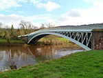 (c) John Grayson, CC BY-SA 2.0
Bigsweir Bridge.
Se även
- Lista över floder i Storbritannien
- Lista över floder i England
- Lista över floder i Wales
Referenser
- Den här artikeln är helt eller delvis baserad på material från engelskspråkiga Wikipedia, River Wye, 13 november 2015.
Fortsatt läsning
- I. Cohen, 'The non-tidal Wye and its navigation' Trans. Woolhope Nat. Fld. Club 34 (1955), 83–101;
- V. Stockinger, The Rivers Wye and Lugg Navigation: a documentary history 1555–1951 (Logaston Press 1996);
- P. King, 'The river Teme and other Midlands River Navigations' Journal of Railway and Canal Historical Society 35(50 (July 2006), 350–1.
- Chisholm, Hugh, ed. (1911). "Wye". Encyclopædia Britannica (11th ed.). Cambridge University Press.
Externa länkar
- Wye beskriven från källa till hav
- Natural England (SSSI information)
- Countryside Council for Wales (SSSI information)
- The Wye and Usk Foundation conservation charity
- Canoeists' guide to the River Wye
- River Wye Preservation Trust
Media som används på denna webbplats

Former railway bridge and viaduct, River Wye, Monmouth - geograph.org.uk - 1179643.jpg
(c) Gareth James, CC BY-SA 2.0
Former railway bridge and viaduct, River Wye, Monmouth
(c) Gareth James, CC BY-SA 2.0
Former railway bridge and viaduct, River Wye, Monmouth

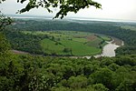
The Wye Valley viewed from Eagle's Nest - geograph.org.uk - 801044.jpg
(c) Philip Halling, CC BY-SA 2.0
The Wye Valley viewed from Eagle's Nest View over the Wye Valley towards Chepstow and the Severn Estuary beyond from the Eagle's Nest a superb viewpoint above Wyndcliff. In the middle distance the River Wye negotiates a large loop around the Lancaut Peninsula.
(c) Philip Halling, CC BY-SA 2.0
The Wye Valley viewed from Eagle's Nest View over the Wye Valley towards Chepstow and the Severn Estuary beyond from the Eagle's Nest a superb viewpoint above Wyndcliff. In the middle distance the River Wye negotiates a large loop around the Lancaut Peninsula.
River Wye at Hay-on-Wye.jpg
(c) Claire Ward, CC BY-SA 2.0
The River Wye at Hay-on-Wye near the border between Wales and England.
(c) Claire Ward, CC BY-SA 2.0
The River Wye at Hay-on-Wye near the border between Wales and England.

Stone train leaving Tintern - geograph.org.uk - 73645.jpg
(c) John Thorn, CC BY-SA 2.0
Stone train leaving Tintern. Tintern Station is on the far right, the train is crossing the River Wye heading towards Chepstow. The line was originally constructed by the Wye Valley Railway.
(c) John Thorn, CC BY-SA 2.0
Stone train leaving Tintern. Tintern Station is on the far right, the train is crossing the River Wye heading towards Chepstow. The line was originally constructed by the Wye Valley Railway.

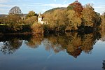
The River Wye at Dixton, Monmouth - geograph.org.uk - 604138.jpg
(c) Philip Halling, CC BY-SA 2.0
The River Wye at Dixton, Monmouth St Peter's church and trees in autumn colour reflected in the River Wye at Dixton just upstream from Monmouth.
(c) Philip Halling, CC BY-SA 2.0
The River Wye at Dixton, Monmouth St Peter's church and trees in autumn colour reflected in the River Wye at Dixton just upstream from Monmouth.


River Wye from the chimneytops - geograph.org.uk - 1629309.jpg
(c) Jonathan Billinger, CC BY-SA 2.0
River Wye from the chimneytops Looking out across the river at Ross-on-Wye from Wilton Road on a cold crisp December morning.
(c) Jonathan Billinger, CC BY-SA 2.0
River Wye from the chimneytops Looking out across the river at Ross-on-Wye from Wilton Road on a cold crisp December morning.
Water transport on River Wye at Symonds Yat East - geograph.org.uk - 721703.jpg
(c) Roger Davies, CC BY-SA 2.0
Water transport on River Wye at Symonds Yat East View in the foreground of the hand ferry on the River Wye tied up outside the Saracen's Head pub at Symonds Yat East. Photo looks downstream. The Kingfisher cruise boat "Wye Pride" is also at her moorings awaiting passengers for an afternoon cruise up river.
Map of the River Wye (West Midlands and Wales, UK).jpeg
Författare/Upphovsman: RobinLovelace, Licens: CC BY-SA 3.0
Outline of central flow of the river, from source to sea. Created using QGIS.
Författare/Upphovsman: RobinLovelace, Licens: CC BY-SA 3.0
Outline of central flow of the river, from source to sea. Created using QGIS.

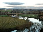
River Wye.jpg
Författare/Upphovsman: AnitaHolford, Licens: CC BY-SA 3.0
River Wye view from Royal Hotel, Ross-on-Wye, Herefordshire
Författare/Upphovsman: AnitaHolford, Licens: CC BY-SA 3.0
River Wye view from Royal Hotel, Ross-on-Wye, Herefordshire

The old railway bridge, Redbrook - geograph.org.uk - 604235.jpg
(c) Philip Halling, CC BY-SA 2.0
The old railway bridge, Redbrook The Wye Valley Railway between Chepstow and Ross on Wye closed pre-Beeching in 1959 though a number of the bridges across the river remain. This bridge at Redbrook also carries a footbridge which is used by the Wye Valley Walk.
(c) Philip Halling, CC BY-SA 2.0
The old railway bridge, Redbrook The Wye Valley Railway between Chepstow and Ross on Wye closed pre-Beeching in 1959 though a number of the bridges across the river remain. This bridge at Redbrook also carries a footbridge which is used by the Wye Valley Walk.
