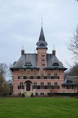
Wuustwezel
| Wuustwezel | |||
| Kommun | |||
Slott inom kommunen Wuustwezel | |||
| |||
| Land | |||
|---|---|---|---|
| Gemenskap | Flamländska gemenskapen | ||
| Region | Flandern | ||
| Provins | Antwerpen | ||
| Arrondissement | Antwerpen | ||
| Koordinater | 51°23′30″N 04°35′45″Ö / 51.39167°N 4.59583°Ö | ||
| Area | 89,43 km² | ||
| Folkmängd | 20 627 (2017-10-01)[1] | ||
| Befolkningstäthet | 231 invånare/km² | ||
| Borgmästare | Dieter Wouters (CD&V) | ||
| Postnummer | 2990 | ||
| Riktnummer | 03 | ||
| Geonames | 2783417 | ||
Wuustwezels läge i Belgien | |||
 Wuustwezels läge i provinsen Antwerpen | |||
| Webbplats: http://www.wuustwezel.be/ | |||
Wuustwezel är en kommun i provinsen Antwerpen i regionen Flandern i Belgien. Wuustwezel hade 20 627 invånare (2017).[1]
Referenser
Externa länkar
 Wikimedia Commons har media som rör Wuustwezel.
- Officiell webbplats för Wuustwezels kommun
Media som används på denna webbplats
The civil ensign and flag of Belgium. It is identical to Image:Flag of Belgium.svg except that it has a 2:3 ratio, instead of 13:15.
Författare/Upphovsman: NordNordWest, Licens: CC BY-SA 3.0
Location map of Belgium
Shiny red button/marker widget. Used to mark the location of something such as a tourist attraction.
Wapenschild van Wuustwezel
Författare/Upphovsman: Funkyxian, Licens: CC BY-SA 3.0
This is a photo of onroerend erfgoed number
Flag of the Belgian commune of Wuustwezel.
The municipal flag of Wuustwezel is quartered per saltire blue-yellow-red-white.


