Wrabness
| Wrabness | |
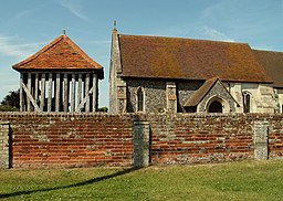
(c) Robert Edwards, CC BY-SA 2.0 | |
| Land | |
|---|---|
| Riksdel | England |
| Region | Östra England |
| Ceremoniellt grevskap | Essex |
| Administrativt grevskap | Essex |
| Distrikt | Tendring |
| Civil parish | Wrabness |
| Koordinater | 51°56′31″N 1°09′50″Ö / 51.9419°N 1.1640°Ö |
| Tidszon | GMT (UTC+0) |
| Geonames | 2633506 7300552 |
Wrabness är en by och en civil parish i Tendring i Essex i England. Orten har 380 invånare (2001).[1] Byn nämndes i Domedagsboken (Domesday Book) år 1086, och kallades då Wrabenasa.[2]
Referenser
- ^ Neighbourhood statistics Arkiverad 7 maj 2016 hämtat från the Wayback Machine.
- ^ http://www.domesdaybook.co.uk/essex5.html#wrabness
Externa länkar
Media som används på denna webbplats
Författare/Upphovsman: Alexrk2, Licens: CC BY-SA 3.0
Location map of the United Kingdom
Shiny red button/marker widget. Used to mark the location of something such as a tourist attraction.
(c) Robert Edwards, CC BY-SA 2.0
All Saints church, Wrabness, Essex. This church dates back to the Norman period and, unlike most churches, a later tower was never added to house the bells. Instead, a timber cage-like structure was built to house the bells in the 17th or 18th centuries. It can be seen on the left in this picture, and it was originally weatherboarded.


