Worthington, Ohio
| Worthington | |
| city | |
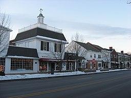
High Street | |
| Land | |
|---|---|
| Delstat | Ohio |
| County | Franklin County |
| Höjdläge | 263 m ö.h. |
| Koordinater | 40°5′35″N 83°1′5″V / 40.09306°N 83.01806°V |
| Yta | 14,4 km² (2010) |
| - land | 14,2 km² |
| - vatten | 0,2 km² |
| Folkmängd | 13 575 (2010) |
| Befolkningstäthet | 956 invånare/km² |
| Tidszon | EST (UTC-5) |
| - sommartid | EDT (UTC-4) |
| ZIP-kod | 43085 |
| Riktnummer | 614 |
| FIPS | 3986604 |
| Geonames | 5177396 |
Ortens läge i Ohio | |
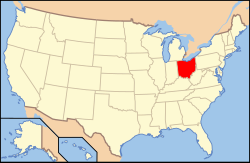
Ohios läge i USA | |
| Webbplats: https://www.worthington.org/ | |
Worthington är en stad (city) i Franklin County i Ohio och en av Columbus norra förorter.[1] Vid 2010 års folkräkning hade Worthington 13 575 invånare.[2]
Kända personer från Worthington
- Newton W. Gilbert, politiker
- Maggie Grace, skådespelare
Källor
- ^ Worthington, OH. Map Quest. Läst 3 augusti 2021.
- ^ 2010 Census Population of Worthington, Ohio. Census Viewer. Läst 3 augusti 2021.
|
Media som används på denna webbplats
Shiny red button/marker widget. Used to mark the location of something such as a tourist attraction.
Författare/Upphovsman: This version: uploader
Base versions this one is derived from: originally created by en:User:Wapcaplet, Licens: CC BY 2.0
Map of USA with Ohio highlighted
Författare/Upphovsman: Alexrk2, Licens: CC BY 3.0
Den här Det karta skapades med GeoTools.
Buildings on the western side of the 600 block of High Street (U.S. Route 23) in downtown Worthington, Ohio, United States. These buildings are part of the Worthington Historic District, a historic district that is listed on the National Register of Historic Places.


