Worcester County, Massachusetts
| Worcester County | ||
| County | ||
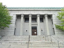
Worcester County Courthouse. | ||
| ||
| Land | ||
|---|---|---|
| Delstat | ||
| Huvudort | Worcester | |
| Area | 4 090 km² (2010)[1] | |
| - land | 3 913 km² (96%) | |
| - vatten | 177 km² (4%) | |
| Folkmängd | 798 552 (2010)[2] | |
| Befolkningstäthet | 204 invånare/km² | |
| Grundat | 2 april 1731 | |
| Tidszon | EST (UTC-5) | |
| - sommartid | EDT (UTC-4) | |
| FIPS-kod | 25027 | |
| Geonames | 4956199 | |
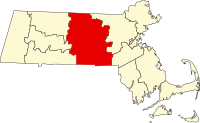
 Läge i delstaten Massachusetts. | ||
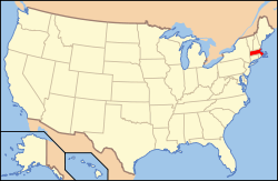
Delstatens läge i USA. | ||
Worcester County är ett område i centrala delen av delstaten Massachusetts i USA. Worcester är ett av fjorton counties i delstaten. Den administrativa huvudorten (county seat) är Worcester. År 2010 hade Worcester County 798 552 invånare.
1998 överfördes den sekundärkommunala verksamheten i countyt till delstatsmyndigheterna.[3]
Geografi
Enligt United States Census Bureau har Worcester County en total area på 4 090 km². 3 919 km² av den arean är land och 171 km² är vatten.
Angränsande countyn
- Cheshire County, New Hampshire - nord
- Hillsborough County, New Hampshire - nord/nordöst
- Middlesex County, Massachusetts - öst/nordöst
- Norfolk County, Massachusetts - öst/sydöst
- Providence County, Rhode Island - syd/sydöst
- Windham County, Connecticut - syd
- Tolland County, Connecticut - syd/sydväst
- Hampden County, Massachusetts - väst/sydväst
- Hampshire County, Massachusetts - väst
- Franklin County, Massachusetts - väst/nordväst
Städer och samhällen
Worcester County ingår i den bredaste definitionen av Greater Boston (Boston-Worcester-Providence Combined Statistical Area).[4]
Städer
Countyt har fem stadskommuner med status av cities:
- Fitchburg
- Gardner
- Leominster
- Southbridge
- Worcester, traditionell huvudort
Övriga kommuner
I New England dit Massachusetts ingår är town den vanligaste kommuntypen och i och med att Worcester County hör till de countyn som har avskaffat countystyrelserna och överfört deras verksamhet till delstatsnivån, är primärkommunen en viktig administrativ enhet. I countyt ingår följande towns:
- Ashburnham
- Athol
- Auburn
- Barre
- Berlin
- Blackstone
- Bolton
- Boylston
- Brookfield
- Charlton
- Clinton
- Douglas
- Dudley
- East Brookfield
- Grafton
- Hardwick
- Harvard
- Holden
- Hopedale
- Hubbardston
- Lancaster
- Leicester
- Lunenburg
- Mendon
- Milford
- Millbury
- Millville
- New Braintree
- North Brookfield
- Northborough
- Northbridge
- Oakham
- Oxford
- Paxton
- Petersham
- Phillipston
- Princeton
- Royalston
- Rutland
- Shrewsbury
- Southborough
- Spencer
- Sterling
- Sturbridge
- Sutton
- Templeton
- Upton
- Uxbridge
- Warren
- Webster
- West Boylston
- West Brookfield
- Westborough
- Westminster
- Winchendon
Källor
- ^ ”2010 Census U.S. Gazetteer Files for Counties”. U.S. Census Bureau. Arkiverad från originalet den 5 juli 2012. https://www.webcitation.org/68vYLbou5?url=http://www.census.gov/geo/www/gazetteer/files/Gaz_counties_national.txt. Läst 5 juli 2012.
- ^ ”State & County QuickFacts, Worcester County, Massachusetts” (på engelska). U.S. Census Bureau. Arkiverad från originalet den 22 juli 2011. https://www.webcitation.org/60NX5WVi3?url=http://quickfacts.census.gov/qfd/states/25/25027.html. Läst 6 juli 2011.
- ^ ”Historical Data Relating to the Incorporation of Counties in the Commonwealth of Massachusetts”. Secretary of the Commonwealth of Massachusetts: Citizen Information Service. http://www.sec.state.ma.us/cis/cisctlist/ctlistcounin.htm. Läst 13 oktober 2009.
- ^ ”Boston-Worcester-Providence, MA-RI-NH-CT Combined Statistical Area” (på engelska). United States Census Bureau. https://www2.census.gov/geo/maps/econ/ec2012/csa/EC2012_330M200US148M.pdf. Läst 13 september 2024.
| ||||||||||
|
Media som används på denna webbplats
The Seal of Worcester County, Massachusetts, originally adopted in 1731 as the seal of the common-law courts and later used by the now-defunct county government. The version seen here is based loosely on one modernized by the Worcester County Sheriff's Office and the original counterpart (#14) The seal reads Sig[illum] Com[itatus] Worces[terensis], N[ova] Ang[lia] or literally "The Seal of the County of Worcester, New England".
This is a locator map showing Worcester County in Massachusetts. For more information, see Commons:United States county locator maps.
Författare/Upphovsman: Daderot, Licens: CC0
The former Worcester County Courthouse, Worcester, Massachusetts, USA. It has the interesting motto: Obedience to Law is Liberty. According to Preservation Worcester, the building was built in stages "(1843, 1878, 1898 and 1954). The south wing is its oldest section, dating from 1843. A Greek revival section was added in 1878. The present Classical Revival structure was built in 1898 and designed by Andrews, Jacques, and Rantoul to incorporate the earlier structures."
Författare/Upphovsman: This version: uploader
Base versions this one is derived from: originally created by en:User:Wapcaplet, Licens: CC BY 2.0
Map of USA with Massachusetts highlighted


