Wissington
| Wissington | |
| Wiston | |
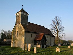
(c) mym, CC BY-SA 2.0 Church of St Mary | |
| Land | |
|---|---|
| Riksdel | England |
| Region | Östra England |
| Ceremoniellt grevskap | Suffolk |
| Administrativt grevskap | Suffolk |
| Distrikt | Babergh |
| Civil parish | Nayland-with-Wissington |
| Koordinater | 51°58′04″N 0°50′49″Ö / 51.9679°N 0.8470°Ö |
| Tidszon | UTC (UTC+0) |
| - sommartid | BST (UTC+1) |
| Geonames | 2633760 |
Läge i Storbritannien | |
Wissington eller Wiston[1] är en by i Nayland-with-Wissington, Babergh, Suffolk, England. Parish hade 191 invånare år 1881.[2] Den har en kyrka.[3][4] År 1884 blev den en del av den då nybildade Nayland-with-Wissington.[5]
Referenser
- ^ ”St Mary's Wissington or Wiston.”. Arkiverad från originalet den 4 mars 2016. https://web.archive.org/web/20160304225228/http://www.naylandandwiston.net/History/Churches/StJames/StMlargephoto.htm. Läst 12 januari 2012.
- ^ ”Population statistics Wissington AP/CP through time”. A Vision of Britain through Time. https://visionofbritain.org.uk/unit/10275155/cube/TOT_POP. Läst 18 december 2021.
- ^ http://www.britishlistedbuildings.co.uk/en-278349-church-of-st-mary-wiston-nayland-with-wi
- ^ http://www.suffolkchurches.co.uk/wissington.htm
- ^ UKBMD. ”Sudbury Registration District”. https://www.ukbmd.org.uk/reg/districts/sudbury.html. Läst 18 december 2021.
Media som används på denna webbplats
Författare/Upphovsman: Alexrk2, Licens: CC BY-SA 3.0
Location map of the United Kingdom
Shiny red button/marker widget. Used to mark the location of something such as a tourist attraction.
(c) mym, CC BY-SA 2.0
Parish church of St Mary the Virgin, Wissington, Suffolk, England, seen from the southwest


