Winthrop, Massachusetts
| Winthrop | |
| town | |
Flygbild över Winthrop. | |
| Land | |
|---|---|
| Delstat | Massachusetts |
| County | Suffolk County |
| Höjdläge | 11 m ö.h. |
| Koordinater | 42°22′30″N 70°58′58″V / 42.37500°N 70.98278°V |
| Yta | 21,5 km² (2010) |
| - land | 15,2 km² |
| - vatten | 6,3 km² |
| Folkmängd | 17 497 (2010) |
| Befolkningstäthet | 1 151 invånare/km² |
| Tidszon | EST (UTC-5) |
| - sommartid | EDT (UTC-4) |
| ZIP-kod | 02152 |
| Riktnummer | 617/857 |
| FIPS | 2580930 |
| Geonames | 4955993 |
Ortens läge i Massachusetts | |
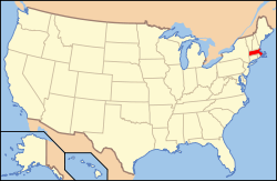
Massachusetts läge i USA | |
| Webbplats: http://www.town.winthrop.ma.us/ | |
Winthrop är en kommun (town) i Suffolk County i Massachusetts.[1] Orten fick sitt namn efter John Winthrop som var guvernör i Massachusetts Bay-kolonin.[2] Enligt 2010 års folkräkning hade Winthrop 17 497 invånare.[3]
Kända personer från Winthrop
- Mike Eruzione, ishockeyspelare
- Stanley Forman, bildjournalist
- Rick DiPietro, ishockeyspelare
- Benjamin Lee Whorf, lingvist
Källor
- ^ Profile for Winthrop, Massachusetts. ePodunk. Läst 4 april 2017.
- ^ Winthrop. Pinterest. Läst 4 april 2017.
- ^ Nahant, Northeastern and SWIM Arkiverad 15 maj 2013 hämtat från the Wayback Machine.. Nahant, Massachusetts. Läst 4 april 2017.
|
Media som används på denna webbplats
Shiny red button/marker widget. Used to mark the location of something such as a tourist attraction.
View of Winthrop, Massachusetts from the northeast, with Logan International Airport and the Boston skyline in the background. A causeway of the Boston, Revere Beach, & Lynn Railroad is visible parallel to the shore in the right center of the image.
Författare/Upphovsman: Alexrk2, Licens: CC BY 3.0
Location map of Massachusetts, USA
Författare/Upphovsman: This version: uploader
Base versions this one is derived from: originally created by en:User:Wapcaplet, Licens: CC BY 2.0
Map of USA with Massachusetts highlighted


