Williams, Arizona
| Williams | |
| Wii Gvʼul | |
| city | |
 Pollock Building | |
| Land | |
|---|---|
| Delstat | Arizona |
| County | Coconino County |
| Höjdläge | 2 062 m ö.h. |
| Koordinater | 35°14′58″N 112°11′28″V / 35.24944°N 112.19111°V |
| Yta | 114,4 km² (2010) |
| - land | 113,5 km² |
| - vatten | 0,9 km² |
| Folkmängd | 3 023 (2010) |
| Befolkningstäthet | 27 invånare/km² |
| Tidszon | MST (UTC-7) |
| ZIP-kod | 86046 |
| Riktnummer | 928 |
| FIPS | 0483160 |
| Geonames | 5321098 |
 Ortens läge i Arizona | |
 Arizonas läge i USA | |
Williams (havasupai: Wii Gvʼul) är en ort i Coconino County i Arizona.[1] Vid 2010 års folkräkning hade Williams 3 023 invånare.[2]
Williams anlades som en järnvägsstation vid Atchison, Topeka and Santa Fe Railway. Staden är också utgångspunkt för bibanan Grand Canyon Railway, som går till Grand Canyon Village.
Bildgalleri
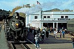
Williams järnvägsstation

Flygfoto, 1941

Källor
Noter
- ^ Williams, AZ. Map Quest. Läst 26 juli 2019.
- ^ 2010 Census Population of Williams, Arizona. Census Viewer. Läst 26 juli 2019.
|
Media som används på denna webbplats


Red pog.svg
Shiny red button/marker widget. Used to mark the location of something such as a tourist attraction.
Shiny red button/marker widget. Used to mark the location of something such as a tourist attraction.
Map of USA AZ.svg
Författare/Upphovsman: Huebi, Licens: CC BY 2.0
Map of USA with Arizona highlighted
Författare/Upphovsman: Huebi, Licens: CC BY 2.0
Map of USA with Arizona highlighted
Williams-Pollock-Building.jpg
Författare/Upphovsman: Steven C. Price, Licens: CC BY-SA 4.0
Pollock Building, 104 N. 3rd Street, Williams, AZ
Författare/Upphovsman: Steven C. Price, Licens: CC BY-SA 4.0
Pollock Building, 104 N. 3rd Street, Williams, AZ
.jpg)
Williams AZ - Air View of Bill Wiliams Mtn. and Wiliams, Arizona (NBY 431231).jpg
Aerial view of Bill Williams Mountain and the city of Williams, Arizona.
Aerial view of Bill Williams Mountain and the city of Williams, Arizona.
USA Arizona location map.svg
Författare/Upphovsman: NordNordWest, Licens: CC BY-SA 3.0
Location map of Arizona, USA
Författare/Upphovsman: NordNordWest, Licens: CC BY-SA 3.0
Location map of Arizona, USA