Whitehall, Ohio
| Whitehall | |
| city | |
| Land | |
|---|---|
| Delstat | Ohio |
| County | Franklin County |
| Höjdläge | 242 m ö.h. |
| Koordinater | 39°58′0″N 82°53′8″V / 39.96667°N 82.88556°V |
| Yta | 13,7 km² (2010) |
| - land | 13,6 km² |
| - vatten | 0,1 km² |
| Folkmängd | 18 062 (2010) |
| Befolkningstäthet | 1 328 invånare/km² |
| Tidszon | EST (UTC-5) |
| - sommartid | EDT (UTC-4) |
| ZIP-kod | 43213 |
| Riktnummer | 614 |
| FIPS | 3984742 |
| Geonames | 4528291 |
Ortens läge i Ohio | |
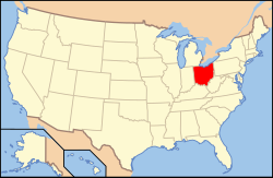
Ohios läge i USA | |
| Webbplats: https://www.whitehall-oh.us/ | |
Whitehall är en ort i Franklin County i Ohio.[1] Vid 2010 års folkräkning hade Whitehall 18 062 invånare.[2]
Källor
- ^ Whitehall, OH. Map Quest. Läst 14 maj 2020.
- ^ 2010 Census Population of Whitehall, Ohio. Census Viewer. Läst 14 maj 2020.
|
Media som används på denna webbplats
Författare/Upphovsman: Alexrk2, Licens: CC BY 3.0
Den här Det karta skapades med GeoTools.
Shiny red button/marker widget. Used to mark the location of something such as a tourist attraction.
Författare/Upphovsman: This version: uploader
Base versions this one is derived from: originally created by en:User:Wapcaplet, Licens: CC BY 2.0
Map of USA with Ohio highlighted
Författare/Upphovsman: Sixflashphoto, Licens: CC BY-SA 4.0
Whitehall Towne Square District Sign taken at the end of November looking from the north.


