Westmorland and Furness
| Westmorland and Furness | |
| Enhetskommun | |
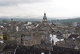
(c) Humphrey Bolton, CC BY-SA 2.0 | |
| Land | |
|---|---|
| Riksdel | England |
| Region | Nordvästra England |
| Ceremoniellt grevskap | Cumbria |
| Koordinater | 54°19′54″N 2°44′51″V / 54.3317°N 2.7475°V |
| Huvudort | Kendal |
| Area | 3 756 km²[1] |
| Folkmängd | 227 643 (2022)[2] |
| Befolkningstäthet | 61 invånare/km² |
| Grundad | 2023 |
| Tidszon | UTC (UTC+0) |
| - sommartid | BST (UTC+1) |
| GSS-kod | E06000064 |
Contains Ordnance Survey data © Crown copyright and database right, CC BY-SA 3.0 Läge i grevskapet Cumbria | |
| Webbplats: https://www.westmorlandandfurness.gov.uk/ | |
Westmorland and Furness är en enhetskommun i det ceremoniella grevskapet Cumbria i England, Storbritannien. Kommunen har 227 643 invånare (2022)[2]. Administrativ huvudort är Kendal.
Den bildades den 1 april 2023 genom en sammanslagning av distrikten Barrow-in-Furness, Eden och South Lakeland.[3] Den har 155 civil parishes.[4]
Större orter är Barrow-in-Furness, Kendal, Penrith och Ulverston.
Referenser
- ^ ”Estimates of the population for the UK, England, Wales, Scotland, and Northern Ireland (Mid-2022)” (på engelska) (xls). Landyta, avrundad till hela km². Office for National Statistics. 26 mars 2024. https://www.ons.gov.uk/peoplepopulationandcommunity/populationandmigration/populationestimates/datasets/populationestimatesforukenglandandwalesscotlandandnorthernireland. Läst 25 juni 2024.
- ^ [a b] ”Estimates of the population for the UK, England, Wales, Scotland, and Northern Ireland (Mid-2022)” (på engelska) (xls). Office for National Statistics. 26 mars 2024. https://www.ons.gov.uk/peoplepopulationandcommunity/populationandmigration/populationestimates/datasets/populationestimatesforukenglandandwalesscotlandandnorthernireland. Läst 25 juni 2024.
- ^ ”The Cumbria (Structural Changes) Order 2022”. legislation.gov.uk. https://www.legislation.gov.uk/uksi/2022/331/made. Läst 1 april 2023.
- ^ ”Children of Westmorland and Furness Council”. Mapit. https://mapit.mysociety.org/area/166594/children.html. Läst 29 juni 2024.
Externa länkar
- Officiell webbplats
 Wikimedia Commons har media som rör Westmorland and Furness.
Media som används på denna webbplats
(c) Humphrey Bolton, CC BY-SA 2.0
Kendal roofscape The buildings of Kendal, especially on the west side of the main street, are very tightly packed, with access from narrow 'yards', many with no name but identified by numbers. The two prominent features are the chimney of the former public baths and the tower of the Town Hall.
Contains Ordnance Survey data © Crown copyright and database right, CC BY-SA 3.0
Map of Cumbria, UK with Westmorland and Furness highlighted.
Equirectangular map projection on WGS 84 datum, with N/S stretched 160%


