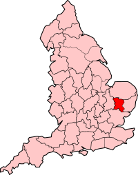
West Suffolk (grevskap)
| West Suffolk | ||
(c) Keith Evans, CC BY-SA 2.0 | ||
| ||
| Land | ||
|---|---|---|
| Riksdel | England | |
| Grevskap | Suffolk | |
| Koordinater | 52°14′33″N 0°43′10″Ö / 52.2425°N 0.7194°Ö | |
| Bury St Edmunds | ||
| Grundad | 1889 | |
| Tidszon | UTC (UTC+0) | |
| - sommartid | BST (UTC+1) | |
| Geonames | 2634259 | |
Läge i Storbritannien | ||
West Suffolk var en grevskap 1889–1974 när det uppgick i Suffolk,[1] i England. Grevskap hade 128 918 invånare år 1961.[2] Bury St Edmunds var det administrativa centrumet.
Distrikt
- Brandon (fram till 1935)
- Bury St Edmunds
- Clare
- Cosford
- Glemsford (1896-1935)
- Hadleigh
- Haverhill
- Melford
- Mildenhall
- Moulton (fram till 1935)
- Newmarket
- Sudbury
- Thedwastre
- Thingoe[3]
Referenser
- ^ ”Local Government Act 1972”. legislation.gov.uk. https://www.legislation.gov.uk/ukpga/1972/70/schedule/1. Läst 19 januari 2024.
- ^ ”Population statistics West Suffolk AdmC through time”. A Vision of Britain through Time. https://visionofbritain.org.uk/unit/10025011/cube/TOT_POP. Läst 19 januari 2024.
- ^ ”Relationships and changes West Suffolk AdmC through time”. A Vision of Britain through Time. https://visionofbritain.org.uk/unit/10025011. Läst 19 januari 2024.
Externa länkar
 Wikimedia Commons har media som rör West Suffolk.
Media som används på denna webbplats
Författare/Upphovsman: Alexrk2, Licens: CC BY-SA 3.0
Location map of the United Kingdom
Shiny red button/marker widget. Used to mark the location of something such as a tourist attraction.
(c) Keith Evans, CC BY-SA 2.0
The Old Shire Hall The old shire hall Bury St.Edmunds Suffolk now a small part of the shire hall complex this building is now houses magistrates courts.


