West Berkshire
| West Berkshire | |
| Enhetskommun | |
| Land | |
|---|---|
| Riksdel | England |
| Region | Sydöstra England |
| Ceremoniellt grevskap | Berkshire |
| Koordinater | 51°25′N 1°15′V / 51.42°N 1.25°V |
| Huvudort | Newbury |
| Area | 704 km²[1] |
| Folkmängd | 162 215 (2022)[2] |
| Befolkningstäthet | 230 invånare/km² |
| Tidszon | UTC (UTC+0) |
| - sommartid | BST (UTC+1) |
| ISO 3166-2-kod | GB-WBK- |
| GSS-kod | E06000037 |
| Geonames | 3333217 |
Contains Ordnance Survey data © Crown copyright and database right, CC BY-SA 3.0 Läge i grevskapet Berkshire | |
West Berkshire är en enhetskommun i Berkshire i England, Storbritannien. Kommunen har 162 215 invånare (2022)[2]. Huvudort är Newbury. Distriktet hette tidigare Newbury, och var en del av det administrativa grevskapet Berkshire. Den 1 april 1998 blev alla distrikt i Berkshire enhetskommuner och distriktet ändrade namn.
West Berkshire är indelat i civil parishes, som används för visst lokalt självstyre:
- Aldermaston
- Aldworth
- Ashampstead
- Basildon (med orten Upper Basildon)
- Beech Hill
- Beedon
- Beenham
- Boxford
- Bradfield
- Brightwalton
- Brimpton
- Bucklebury
- Burghfield
- Catmore
- Chaddleworth
- Chieveley
- Cold Ash
- Combe
- Compton
- East Garston
- East Ilsley
- Enborne
- Englefield
- Farnborough
- Fawley
- Frilsham
- Great Shefford
- Greenham
- Hampstead Marshall
- Hampstead Norreys
- Hermitage
- Holybrook (med del av orten Calcot)
- Hungerford
- Inkpen
- Kintbury
- Lambourn
- Leckhampstead
- Midgham
- Newbury
- Padworth
- Pangbourne
- Peasemore
- Purley on Thames
- Shaw cum Donnington
- Speen
- Stanford Dingley
- Stratfield Mortimer
- Streatley
- Sulham
- Sulhamstead
- Thatcham
- Theale
- Tidmarsh
- Tilehurst (med del av orten Calcot)
- Ufton Nervet
- Wasing
- Welford (med orten Wickham)
- West Ilsley
- West Woodhay
- Winterbourne
- Wokefield
- Woolhampton
- Yattendon
Källor
- ^ ”Estimates of the population for the UK, England, Wales, Scotland, and Northern Ireland (Mid-2022)” (på engelska) (xls). Landyta, avrundad till hela km². Office for National Statistics. 26 mars 2024. https://www.ons.gov.uk/peoplepopulationandcommunity/populationandmigration/populationestimates/datasets/populationestimatesforukenglandandwalesscotlandandnorthernireland. Läst 25 juni 2024.
- ^ [a b] ”Estimates of the population for the UK, England, Wales, Scotland, and Northern Ireland (Mid-2022)” (på engelska) (xls). Office for National Statistics. 26 mars 2024. https://www.ons.gov.uk/peoplepopulationandcommunity/populationandmigration/populationestimates/datasets/populationestimatesforukenglandandwalesscotlandandnorthernireland. Läst 25 juni 2024.
Externa länkar
 Wikimedia Commons har media som rör West Berkshire.
Media som används på denna webbplats
Contains Ordnance Survey data © Crown copyright and database right, CC BY-SA 3.0
Map of Berkshire, UK with West Berkshire highlighted.
Equirectangular map projection on WGS 84 datum, with N/S stretched 160%Författare/Upphovsman: Tom Bastin from Reading, UK, Licens: CC BY 2.0
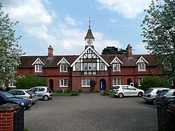
Church and Child's Almshouses, Newtown Road, Newbury. Designed by J H Money and completed in 1879, restored 1982.


