Weddellhavet
| Weddellhavet | |
| Hav | |
| Kontinent | Antarktis |
|---|---|
| Koordinater | 73°S 45°V / 73°S 45°V |
| Geonames | 4036624 |
 | |
Weddellhavet är ett randhav till Antarktiska oceanen. Det ligger mellan Antarktiska halvön och Dronning Maud Land. Havets södra del är alltid täckt med shelfis. Hela havet är 2,8 miljoner kvadratkilometer stort och 500 till 5 000 meter djupt. Havet har fått sitt namn från den skotska polarforskaren James Weddell, som upptäckte havet 1823.
Argentina och Storbritannien gör anspråk på området.
Havet har ett mångsidigt djurliv. Mest känd är sälarten weddellsäl.
Historia
Havet fick sitt namn efter den brittiske upptäcktsresanden James Weddell som 1823 seglade genom havet. Den 12 februari 1903 fastnade Otto Nordenskjölds skepp "Antarctic" i isen och sjönk. Hela manskapet vandrade 16 dagar över isen och nådde sedan en liten ö där de stannade över vintern. Tio månader senare blev de bärgade. Ruinerna av deras provisoriska stenhus finns än idag.
Samma öde drabbade Ernest Henry Shackleton och hans 27 män år 1915. Efter många månader på packisen lyckades de nå Elefantön där männen övervintrade i fyra och en halv månader i väntan på att Shackleton hämtade ett skepp och de kunde återvända år 1917. Vraket av hans fartyg Endurance lokaliserades och filmades 2022, sex kilometer från dess förväntade plats, på ett djup av 3008 meter.[1]
Bilder
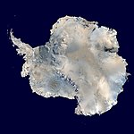
Ortografisk karta över Antarktis

Elefantön, vid randen av Weddellhavet.
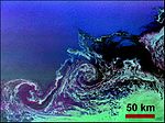
Eddyströmmar i Weddellhavet.


Källor
- ^ ”Endurance: Shackleton's lost ship is found in Antarctic” (på brittisk engelska). BBC News. 9 mars 2022. https://www.bbc.com/news/science-environment-60662541. Läst 9 mars 2022.
Media som används på denna webbplats

Shiny red button/marker widget. Used to mark the location of something such as a tourist attraction.
.jpg)
Författare/Upphovsman: NASA Goddard Space Flight Center from Greenbelt, MD, USA, Licens: CC BY 2.0
Small tabular icebergs, in the marginal ice zone, northern Weddell Sea, as seen during an Operation IceBridge flight on Nov. 22, 2017. (NASA/John Sonntag)
The 2017 field season was record-breaking for Operation IceBridge, NASA’s aerial survey of the state of polar ice. For the first time in its nine-year history, the mission, which aims to close the gap between two NASA satellite campaigns that study changes in the height of polar ice, carried out seven field campaigns in the Arctic and Antarctic in a single year. In total, the IceBridge scientists and instruments flew over 214,000 miles, the equivalent of orbiting the Earth 8.6 times at the equator.
The mission of Operation IceBridge, NASA’s longest-running airborne mission to monitor polar ice, is to collect data on changing polar land and sea ice and maintain continuity of measurements between ICESat missions. The original ICESat mission launched in 2003 and ended in 2009, and its successor, ICESat-2, is scheduled for launch in the fall of 2018. Operation IceBridge began in 2009 and is currently funded until 2020. The planned overlap with ICESat-2 will help scientists connect with the satellite’s measurements.
Read more: <a href="http://www.nasa.gov/feature/goddard/2018/big-year-for-icebridge" rel="nofollow">www.nasa.gov/feature/goddard/2018/big-year-for-icebridge</a>
For more about Operation IceBridge and to follow future campaigns, visit: <a href="http://www.nasa.gov/icebridge" rel="nofollow">www.nasa.gov/icebridge</a>
NASA Goddard Space Flight Center enables NASA’s mission through four scientific endeavors: Earth Science, Heliophysics, Solar System Exploration, and Astrophysics. Goddard plays a leading role in NASA’s accomplishments by contributing compelling scientific knowledge to advance the Agency’s mission.
Follow us on Twitter
Like us on Facebook
Find us on <a href="http://instagrid.me/nasagoddard/?vm=grid" rel="nofollow">Instagram</a>Författare/Upphovsman: Alexrk2, Licens: CC BY-SA 3.0
Physical Location map Antarctica, Azimuthal equidistant projection

Antarctica. An orthographic projection of NASA's Blue Marble data set (1 km resolution global satellite composite). "MODIS observations of polar sea ice were combined with observations of Antarctica made by the National Oceanic and Atmospheric Administration’s AVHRR sensor—the Advanced Very High Resolution Radiometer." Image was generated using a custom C program for handling the Blue Marble files, with orthographic projection formulas from MathWorld.
Note: this image has been manually modified to fill in an area of black pixels in the ocean, in the upper right quadrant. The black pixels are presumed to be due to missing data in the land/sea mask used in making the original Blue Marble image.