Wayne, New Jersey
| Wayne | |
| township | |
Van Riper-Hopper House | |
| Land | |
|---|---|
| Delstat | New Jersey |
| County | Passaic County |
| Höjdläge | 100 m ö.h. |
| Koordinater | 40°56′45″N 74°14′12″V / 40.94583°N 74.23667°V |
| Yta | 65,2 km² (2010) |
| - land | 61,7 km² |
| - vatten | 3,5 km² |
| Folkmängd | 54 717 (2010) |
| Befolkningstäthet | 887 invånare/km² |
| Tidszon | EST (UTC-5) |
| - sommartid | EDT (UTC-4) |
| FIPS | 3477840 |
| Geonames | 7259148 |
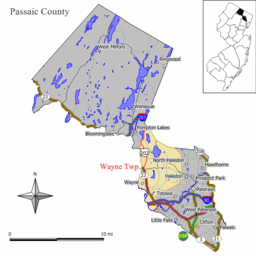
Waynes läge i Passaic County och countyts läge i New Jersey | |
New Jerseys läge i USA | |
Wayne är en kommun (township) i Passaic County i den amerikanska delstaten New Jersey. Wayne tillhör den västra delen av New Yorks storstadsregion och är säte för William Paterson University.[1][2]
Orter och områden
Kommunen Township of Wayne, New Jersey innehåller följande distinkta orter och geografiska områden som alla helt eller delvis administreras som del av kommunen; Barbours Mills, Barbours Pond, Lower Preakness, Mountain View, Packanack Lake, Pines Lake, Point View, Pompton Falls, Preakness och Two Bridges.
Kända personer från Wayne
- Robert A. Roe, politiker
Källor
- ^ University Facts. William Paterson University. Läst 17 juli 2014.
- ^ Contact Us Arkiverad 26 juli 2014 hämtat från the Wayback Machine.. William Paterson University. Läst 17 juli 2014.
Media som används på denna webbplats
Författare/Upphovsman: This version: uploader
Base versions this one is derived from: originally created by en:User:Wapcaplet, Licens: CC BY 2.0
Map of USA with New Jersey highlighted
The Van Riper-Hopper House, which was constructed in 1786, is seen from the front in mid-December, 2011. The house, which is listed on both the National and New Jersey Register of Historic Places, is currently used as a museum by the Township of Wayne, New Jersey.
(c) JimIrwin from en.wikipedia.org, CC BY-SA 3.0
Map of Wayne Township in Passaic County, New Jersey.


