Voyager 1
- För andra betydelser, se Voyager.
 Voyager 1 | |
| Status | aktiv |
|---|---|
| Typ | förbiflygare |
| Program | Voyagerprogrammet |
| Organisation | Nasa |
| NSSDC-ID | 1977-084A[1] |
| Webbplats | http://voyager.jpl.nasa.gov/ |
| Uppskjutning | |
| Uppskjutningsplats | Cape Canaveral LC-41 |
| Uppskjutning | 5 september 1977, 12:56:00 UTC (för 47 år och 183 dagar sedan) |
| Uppskjutningsfarkost | Titan 3E Centaur |
| Förbiflygning av Jupiter | |
| Datum | 5 mars 1979 |
| Minsta avstånd | 349 000 km |
| Förbiflygning av Saturnus | |
| Datum | 12 november 1980 |
| Minsta avstånd | 124 000 km |
| Förbiflygning av Titan | |
| Datum | 12 november 1980 |
| Minsta avstånd | 6 490 km |
| Egenskaper | |
| Massa | 721,86 kg |
| Effekt | 420 W |
Voyager 1 är en obemannad rymdsond i Voyagerprogrammet som skickades upp i rymden av Nasa den 5 september 1977, med en Titan 3E Centaur-raket. Farkosten är det av människan tillverkade föremål som befinner sig längst bort från jorden. Den är identisk med systersonden Voyager 2. Båda farkosterna sändes ut för att undersöka planeter i solsystemet och sände tillbaka bilder och mätdata som helt har förändrat synen på våra grannplaneter. Bland annat har den av Voyager 1 tagna bilden Bleka blå pricken fått stor uppmärksamhet.
Bland Voyager 1:s främsta upptäckter räknas Jupitermånen Ios aktiva vulkaner. Upptäckten var oväntad eftersom inga spår av vulkanismen hade märkts från jordbaserade observationer eller de tidigare förbipasserande sonderna Pioneer 10 och Pioneer 11. Voyager 1 tog de första närbilderna av Jupiters och Saturnus månar, och upptäckte nya ringar kring båda jätteplaneterna. Sonden avslöjade även att Stora röda fläcken på Jupiter var ett enormt stormsystem.
När Voyager 1 närmade sig Saturnus största måne Titan ändrades dess kurs för att göra en nära passage. Voyager 1 saknade tillräckliga instrument för att genomtränga Titans oväntat täta atmosfär. Kursändringen medförde även att sonden inte kunde styras förbi någon av de yttre himlakropparna Uranus och Neptunus. En förbiflygning av dessa gjordes dock av Voyager 2.
Last
Förutom vetenskapliga instrument har Voyagersonderna utrustats med varsin grammofonskiva: Voyager Golden Record. De innehåller bland annat ljud och bilder som skildrar livet och olika kulturer på Jorden. Att skicka med skivan är mer en symbolisk handling än avsedd att bli hittad av något intelligent utomjordiskt liv, då farkosterna rör sig i ett, med galaktiska mått, mycket begränsat område.
Avståndet Voyager 1 befinner sig på


I november 2015 befann sig Voyager 1 på ett avstånd av 133 astronomiska enheter från solen, vilket motsvarar strax under 20 miljarder kilometer.[2] Detta avstånd innebär att det tar drygt 18,5 timmar att sända en signal till Voyager 1, trots att signalen färdas med ljusets hastighet. Som jämförelse tar det bara drygt 8 minuter för solens ljus, eller en radiosignal från solen, att nå jorden. Voyager 1 färdas med en hastighet av drygt 17 km/s, vilket får till följd att fördröjningen för en signal att nå fram ökar med cirka 30 minuter för varje år som går.
I mitten av december 2010 meddelade Nasa att Voyager 1 befann sig på ett avstånd av 17,4 miljarder kilometer från solen och lämnat den zon där solvinden driver utåt från solen. Vetenskapsmän antar att solvinden har tvingats åt sidan av trycket från den interstellära vinden i området mellan stjärnorna. Detta är en milstolpe i Voyager 1:s färd, eftersom den har lämnat heliosfären.
Den 12 september 2013 meddelade den amerikanska rymdflygstyrelsen NASA, att rymdsonden i augusti 2012 lämnade vårt solsystem och är på väg ut i Vintergatan i interstellära rymden. Det är första gången i världshistorien ett människoskapat föremål tar sig utanför den så kallade heliosfären, som sträcker sig minst 13 miljarder kilometer bortom planeterna i vårt solsystem (De tidigare uppskjutna Pioneer 10 och Pioneer 11 var vid denna tidpunkt inte lika långt bort och kontakten var då förlorad med båda).[3][4]
I mars 2018 rapporterades att tekniker vid NASA, efter 37 år, åter hade startat sondens drivraketer. Detta då sondens styrraketer började fungera sämre och kräva allt mer av den tillgängliga energin. I december 2017 skickade man nya signaler och efter 40 timmar (2 x 20 timmar) kom svaret att raketerna svarat och att sonden nu ändrat riktning. Orsaken till manövern är att positionera Voyagers antenn så att den pekar mot jorden. Samtidigt meddelade man att fyra av sondens instrument fortfarande fungerar, varav magnetometern är den viktigaste.[5]

Se även
Källor
Fotnoter
- ^ ”NASA Space Science Data Coordinated Archive” (på engelska). NASA. https://nssdc.gsfc.nasa.gov/nmc/spacecraft/display.action?id=1967-008A. Läst 27 mars 2020.
- ^ ”Where are the Voyagers?” (på engelska). Voyager - The Interstellar Mission. Jet Propulsion Laboratory. http://voyager.jpl.nasa.gov/where/. Läst 2 november 2015.
- ^ ”NASA Spacecraft Embarks on Historic Journey Into Interstellar Space”. nasa.gov. Arkiverad från originalet den 11 juni 2020. https://web.archive.org/web/20200611233345/https://www.nasa.gov/mission_pages/voyager/voyager20130912.html#.UjIZxT89XiF. Läst 12 september 2013.(engelska)
- ^ Morin, Monte (12 september 2013). ”NASA confirms Voyager 1 has left the Solar System”. Los Angeles Times. http://www.latimes.com/science/sciencenow/la-sci-sn-nasa-confirms-voyager-1-has-exited-the-solar-system-20130912,0,3406650.story.
- ^ ”Voyager 1 startade motorerna efter 37 år”. SVT Nyheter. 25 mars 2018. Arkiverad från originalet den 11 januari 2019. https://web.archive.org/web/20190111124543/https://www.svt.se/nyheter/vetenskap/voyager-1-startade-motorerna-efter-37-ar.
| |||||||||||||||||||||||||||||||||||||||||||||||||
| ||||||||||||||||||||||||||||
Media som används på denna webbplats
This image shows the locations of Voyagers 1 and 2. Voyager 1 is traveling a lot and has crossed into the heliosheath, the region where interstellar gas and solar wind start to mix.
Suggested for English Wikipedia:alternative text for images: orange area at left labeled Bow Shock appears to compress a pale blue oval-shaped region labeled Heliosphere extending to the right with its border labeled Heliopause. A central dark blue circular region is labeled Termination Shock with the gap between it and the Heliosphere labeled Heliosheath. Centred in the blue region is a concentric set of ellipses around a bright spot with two white lines curving away from it: the upper line labeled Voyager 1 ends outside the dark blue circle; the lower line labeled Voyager 2 appears inside.
Remark: This picture is from 2005. Today (3 October 2018) Voyager 1 is well beyond the Heliopause and Voyager 2 is about to cross the Heliopause soon (see the latest "3 October 2018" image).[1] Further, there has been evidence that the Bow Shock does not exist; whether the Heliosheath has this long of a tail is doubtful, too. It might be almost spherical.NASA photograph of one of the two identical Voyager space probes Voyager 1 and Voyager 2 launched in 1977.
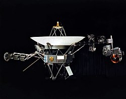
The 3.7 metre diameter high-gain antenna (HGA) is attached to the hollow ten-sided polygonal body housing the electronics, here seen in profile. The Voyager Golden Record is attached to one of the bus sides.
The angled square panel below is the optical calibration target and excess heat radiator.
The three radioisotope thermoelectric generators (RTGs) are mounted end-to-end on the left-extending boom. One of the two planetary radio and plasma wave antenna extends diagonally left and down, the other extends to the rear, mostly hidden here. The compact structure between the RTGs and the HGA are the high-field and low-field magnetometers (MAG) in their stowed state; after launch an Astromast boom extended to 13 metres to distance the low-field magnetometers.
The instrument boom extending to the right holds, from left to right: the cosmic ray subsystem (CRS) above and Low-Energy Charged Particle (LECP) detector below; the Plasma Spectrometer (PLS) above; and the scan platform that rotates about a vertical axis.
The scan platform comprises: the Infrared Interferometer Spectrometer (IRIS) (largest camera at right); the Ultraviolet Spectrometer (UVS) to the right of the UVS; the two Imaging Science Subsystem (ISS) vidicon cameras to the left of the UVS; and the Photopolarimeter System (PPS) barely visible under the ISS.
Suggested for English Wikipedia:alternative text for images: A space probe with squat cylindrical body topped by a large parabolic radio antenna dish pointing upwards, a three-element radioisotope thermoelectric generator on a boom extending left, and scientific instruments on a boom extending right. A golden disk is fixed to the body.Original caption: This narrow-angle color image of the Earth, dubbed ‘Pale Blue Dot’, is a part of the first ever ‘portrait’ of the solar system taken by Voyager 1. The spacecraft acquired a total of 60 frames for a mosaic of the solar system from a distance of more than 4 billion miles from Earth and about 32 degrees above the ecliptic. From Voyager's great distance Earth is a mere point of light, less than the size of a picture element even in the narrow-angle camera. Earth was a crescent only 0.12 pixel in size. Coincidentally, Earth lies right in the center of one of the scattered light rays resulting from taking the image so close to the sun. This blown-up image of the Earth was taken through three color filters – violet, blue and green – and recombined to produce the color image. The background features in the image are artifacts resulting from the magnification.
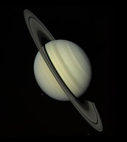
NASA's Voyager 1 took this photograph of Saturn on Oct. 18, 1980, 34 million kilometers (21.1 million miles) from the planet. The photograph was taken on the last day that Saturn and its rings could be captured within a single narrow-angle camera frame as the spacecraft closed in on the planet for its nearest approach on Nov. 12. Dione, one of Saturn's inner satellites, appears as three color spots just below the planet's south pole. An abundance of previously unseen detail is apparent in the rings. For example, a gap in the dark, innermost ring, called the C-ring or crepe ring, is clearly shown. Material is seen within the relatively wide Cassini Division, separating the middle, B-ring from the outermost ring, the A-ring. The Encke Division is shown near the outer edge of the A-ring. The detail in the rings' shadows cast on the planet is of particular interest: the broad, dark band near the equator is the shadow of the B-ring; the thinner, brighter line is just to the south of the shadow of the less dense A-ring.
Readings from LA1 instrument on Voyager 1 consisting of collisions of greater than 0.5 MeV/nuc nuclei, principally protons, and is sensitive to low-energy phenomena in interplanetary space
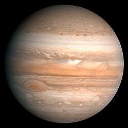
Original Caption Released with Image: This processed color image of Jupiter was produced in 1990 by the U.S. Geological Survey from a Voyager 2 image captured in 1979. The colors have been enhanced to bring out detail. Zones of light-colored, ascending clouds alternate with bands of dark, descending clouds. The clouds travel around the planet in alternating eastward and westward belts at speeds of up to 540 kilometers per hour. Tremendous storms as big as Earthly continents surge around the planet. The Great Red Spot (oval shape toward the lower-left) is an enormous anticyclonic storm that drifts along its belt, eventually circling the entire planet.
(c) 7Train at the English Wikipedia, CC BY-SA 3.0
This file is completely inaccurate and should be deleted. See this discussion: https://space.stackexchange.com/a/48082 Produced with Adobe Illustrator CS4. 7/2/07.


