Vorderrhein
| Den här artikeln behöver källhänvisningar för att kunna verifieras. (2024-05) Åtgärda genom att lägga till pålitliga källor (gärna som fotnoter). Uppgifter utan källhänvisning kan ifrågasättas och tas bort utan att det behöver diskuteras på diskussionssidan. |
| Vorderrhein | |
| Rein Anteriur | |
| Vattendrag | |
Vorderrhein vid Ruinaulta. | |
| Land | |
|---|---|
| Koordinater | 46°49′25″N 9°24′28″Ö / 46.82361°N 9.40778°Ö |
| Tidszon | CET (UTC+1) |
| - sommartid | CEST (UTC+2) |
| Geonames | 2658098 |
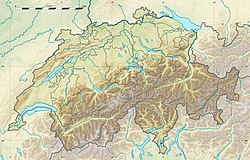
Vorderrhein är en av Rhens källfloder. Den möter Hinterrhein vid Tamins i kantonen Graubünden, Schweiz (koordinaterna pekar på mynningen).
Media som används på denna webbplats
Författare/Upphovsman: Tkgd2007, Licens: CC BY-SA 3.0
A new incarnation of Image:Question_book-3.svg, which was uploaded by user AzaToth. This file is available on the English version of Wikipedia under the filename en:Image:Question book-new.svg
Författare/Upphovsman: Eric Gaba (Sting - fr:Sting) and NordNordWest, Licens: CC BY-SA 3.0
Blank physical map of Switzerland, for geo-location purpose. More maps: → Maps of Switzerland.
Shiny red button/marker widget. Used to mark the location of something such as a tourist attraction.
Författare/Upphovsman: upload by Adrian Michael, Licens: CC BY 2.5
View from the viewing platform Il spir below Flims Conn of the Rhine bend in the nationally important Ruinaulta with the bridge of the Rhaetian Railway and pedestrian bridge between the Chli Isla (centre of picture) and the Isla Bella (at the left edge of the picture).


