Viry-Châtillon
| Viry-Châtillon | ||
| Kommun | ||
 | ||
| ||
| Land | ||
|---|---|---|
| Region | ||
| Departement | ||
| Arrondissement | Évry | |
| Kanton | Viry-Châtillon | |
| Koordinater | 48°40′N 2°23′Ö / 48.667°N 2.383°Ö | |
| Yta | 6,07 km²[1] | |
| Folkmängd | 31 045 ()[2] | |
| Befolkningstäthet | 5 114 invånare/km² | |
| Borgmästare | Jean-Marie Vilain (2014–)[3] | |
| Tidszon | CET | |
| - sommartid | CEST | |
| Postnummer | 91170 | |
| INSEE | 91687 | |
| Geonames | 6446231 | |
| OSM-karta | 92313 | |
 Kommunens läge i regionen Île-de-France i Frankrike. | ||
| Webbplats: http://www.viry-chatillon.fr | ||

Viry-Châtillon är en kommun i departementet Essonne i regionen Île-de-France i norra Frankrike. Kommunen ligger i kantonen Viry-Châtillon som tillhör arrondissementet Évry. År 2021 hade Viry-Châtillon 31 045 invånare.
Staden är belägen ca 21 km söder om centrala Paris.
Befolkningsutveckling
Antalet invånare i kommunen Viry-Châtillon
 Referens: INSEE[4] |
Galleri
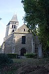 Kyrkan Saint-Denis
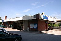 Järnvägsstationen
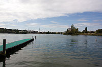 Utsikt över sjön Lac de Viry-Châtillon
Se även
Källor
- ^ Répertoire géographique des communes, Institut national de l'information géographique et forestière, läst: 26 oktober 2015.[källa från Wikidata]
- ^ Populations légales 2021, Institut National de la Statistique et des Études Économiques, 28 december 2023.[källa från Wikidata]
- ^ Inrikesministeriet, Franska nationella registret över valda tjänstemän, läst: 15 mars 2019.[källa från Wikidata]
- ^ Chiffres clés - Évolution et structure de la population hämtat från the Wayback Machine (arkiverat 4 maj 2012).
Externa länkar
 Wikimedia Commons har media som rör Viry-Châtillon.
Media som används på denna webbplats


(c) Katepanomegas, CC BY-SA 3.0
Ancient Coat of arms of France. Azure semy-de-lis Or.
Författare/Upphovsman: Eric Gaba (Sting - fr:Sting), Licens: CC BY-SA 4.0
Blank physical map of metropolitan France for geo-location purpose.
Scale : 1:14 816 000 (accuracy : about 3,7 km) for the bathymetry. More maps of France, view → Commons Atlas of France.

Shiny red button/marker widget. Used to mark the location of something such as a tourist attraction.


Författare/Upphovsman: Poudou99, Licens: CC BY-SA 3.0
Gare de Viry-Châtillon.

Författare/Upphovsman: Poudou99, Licens: CC BY 3.0
Eglise Saint-Denis de Viry-Chatillon, Viry-Chatillon, Essonne, France
.svg)
Författare/Upphovsman: Poudou99, Licens: CC BY 3.0
Mairie de Viry-Châtillon, Viry-Châtillon, Essonne, France
Författare/Upphovsman: Michiel1972, Licens: CC BY-SA 3.0
Population - Municipality code 91687.svg
Population Census 1962-2008Författare/Upphovsman:
|
Map data (c) OpenStreetMap contributors, CC-BY-SA _French_municipality_map.svg) • Shape files infrastructure: railway, highways, water: all originally by OpenStreetMap contributors. Status december 2011 *note: shown commune boundaries are from OSM dump May 2012; at that time about 90% complete |
Map of French municipality Viry-Châtillon

Författare/Upphovsman: Poudou99, Licens: CC BY 3.0
Le lac de Viry-Châtillon, Viry-Chatillon, Essonne, France