Villers-Bocage, Calvados
| Villers-Bocage | ||
| Kommun | ||
 | ||
| ||
| Land | ||
|---|---|---|
| Region | Normandie | |
| Departement | ||
| Arrondissement | Caen | |
| Kanton | Villers-Bocage | |
| Koordinater | 49°5′N 0°39′V / 49.083°N 0.650°V | |
| Yta | 5,76 km²[1] | |
| Folkmängd | 3 113 ()[2] | |
| Befolkningstäthet | 540 invånare/km² | |
| Tidszon | CET (UTC+1) | |
| - sommartid | CEST (UTC+2) | |
| Postnummer | 14310 | |
| INSEE | 14752 | |
| Geonames | 6427560 | |
| OSM-karta | 280629 | |
 Kommunens läge i regionen Normandie i Frankrike | ||
| Webbplats: https://www.villersbocage14.fr | ||

Villers-Bocage är en kommun i departementet Calvados i regionen Normandie i norra Frankrike. Kommunen ligger i kantonen Villers-Bocage som ligger i arrondissementet Caen. År 2022 hade Villers-Bocage 3 113 invånare.
Befolkningsutveckling
Antalet invånare i kommunen Villers-Bocage
Referens:INSEE[3]
Galleri
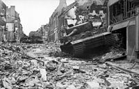 (c) Bundesarchiv, Bild 101I-494-3376-12A / Zwirner / CC-BY-SA 3.0Bild på huvudgatan efter slaget vid Villers-Bocage 13 juni 1944.
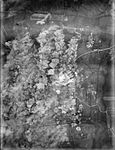 Villers-Bocage efter en bombräd av Storbritannien 30 juni 1944.
Se även
Källor
- ^ Répertoire géographique des communes, Institut national de l'information géographique et forestière, läst: 26 oktober 2015.[källa från Wikidata]
- ^ Populations légales 2022, Institut National de la Statistique et des Études Économiques, 19 december 2024.[källa från Wikidata]
- ^ Chiffres clés - Évolution et structure de la population Arkiverad 5 juli 2012 hämtat från the Wayback Machine.
Media som används på denna webbplats


Författare/Upphovsman: Eric Gaba (Sting - fr:Sting), Licens: CC BY-SA 4.0
Blank physical map of metropolitan France for geo-location purpose.
Scale : 1:14 816 000 (accuracy : about 3,7 km) for the bathymetry. More maps of France, view → Commons Atlas of France.

Shiny red button/marker widget. Used to mark the location of something such as a tourist attraction.
.svg)

Avro Lancasters carpet bomb a road junction near Villers Bocage, Normandy, France through which the 2nd and 9th SS Panzer Divisions were expected to move to carry out an attack on the junction of the British and American armies. The daylight attack, by 266 aircraft of Nos. 3, 4 and 8 Groups, was carried out at 4,000 feet to ensure that the target indicators dropped by the Pathfinders were seen and 1,100 tons of bombs were dropped with great accuracy.
Författare/Upphovsman: hamon jp, Licens: CC BY-SA 3.0
The Town hall of Villers-Bocage.

(c) Bundesarchiv, Bild 101I-494-3376-12A / Zwirner / CC-BY-SA 3.0
Författare/Upphovsman:
|
Map data (c) OpenStreetMap contributors, CC-BY-SA _French_municipality_map.svg) • Shape files infrastructure: railway, highways, water: all originally by OpenStreetMap contributors. Status december 2011 *note: shown commune boundaries are from OSM dump May 2012; at that time about 90% complete |
Map commune FR insee code 14752.png