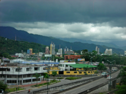
Villavicencio
| Villavicencio | |
| Kommun | |
Vy över Villavicencio. | |
| Land | |
|---|---|
| Departement | Meta |
| Höjdläge | 326 m ö.h. |
| Koordinater | 4°04′27″N 73°29′29″V / 4.07424°N 73.4915°V |
| Folkmängd | 380 222 (2015-04-04)[1] |
| Tidszon | COT (UTC-5) |
| Geonames | 3665901 |
Läge i Colombia | |
Villavicencio är en kommun och stad i Colombia.[1] Den ligger i departementet Meta, i den centrala delen av landet, 90 km sydost om huvudstaden Bogotá. Antalet invånare i kommunen är 380 222.[1] Villavicencio är administrativ huvudort för departementet Meta och centralorten hade 387 144 invånare år 2008.[2]
Källor
- ^ [a b c] Villavicencio at GeoNames.Org (cc-by); post uppdaterad 2015-04-04; databasdump nerladdad 2015-05-23
- ^ Departamento Administrativo Nacional de Estadística. Proyecciones de población municipales por área, 2005-2009, a junio 30. (excelfil)
Media som används på denna webbplats
Författare/Upphovsman: Grundkarte Milenioscuro, Relief Alexrk2, Licens: CC BY-SA 3.0
Physical Location map of Colombia Equirectangular projection. Geographic limits of the map:
Shiny red button/marker widget. Used to mark the location of something such as a tourist attraction.
Författare/Upphovsman: David from Miami, United states, Licens: CC BY 2.0
City of Monteria, Colombia


