Vertou
| Vertou | ||
| Kommun | ||
| ||
| Land | ||
|---|---|---|
| Region | ||
| Departement | ||
| Arrondissement | Nantes | |
| Kanton | Vertou | |
| Koordinater | 47°10′N 1°29′V / 47.167°N 1.483°V | |
| Yta | 35,68 km²[1] | |
| Folkmängd | 26 002 ()[2] | |
| Befolkningstäthet | 729 invånare/km² | |
| Tidszon | CET (UTC+1) | |
| - sommartid | CEST (UTC+2) | |
| Postnummer | 44120 | |
| INSEE | 44215 | |
| Geonames | 2969612 6434558 | |
| OSM-karta | 63642 | |
 Kommunens läge i regionen Pays de la Loire i Frankrike | ||
| Webbplats: http://www.vertou.fr | ||


Vertou är en kommun i departementet Loire-Atlantique i regionen Pays-de-la-Loire i Frankrike. Den är en förort till Nantes och hade 26 002 invånare i början av 2021, på en yta av 35,68 km².
Befolkningsutveckling
Antalet invånare i kommunen Vertou
 Referens: INSEE[3] |
Galleri
Se även
Källor
- ^ Répertoire géographique des communes, Institut national de l'information géographique et forestière, läst: 26 oktober 2015.[källa från Wikidata]
- ^ Populations légales 2021, Institut National de la Statistique et des Études Économiques, 28 december 2023.[källa från Wikidata]
- ^ Chiffres clés - Évolution et structure de la population hämtat från the Wayback Machine (arkiverat 4 maj 2012).
Externa länkar
 Wikimedia Commons har media som rör Vertou.
Media som används på denna webbplats
Författare/Upphovsman: Eric Gaba (Sting - fr:Sting), Licens: CC BY-SA 4.0
Blank physical map of metropolitan France for geo-location purpose.
Scale : 1:14 816 000 (accuracy : about 3,7 km) for the bathymetry. More maps of France, view → Commons Atlas of France.
Shiny red button/marker widget. Used to mark the location of something such as a tourist attraction.
Författare/Upphovsman:
|
Map data (c) OpenStreetMap contributors, CC-BY-SA  • Shape files infrastructure: railway, highways, water: all originally by OpenStreetMap contributors. Status december 2011 *note: shown commune boundaries are from OSM dump May 2012; at that time about 90% complete |
Map commune FR insee code 44215.png
Författare/Upphovsman: User:Poulpy, from an image by Utilisateur:Zot
Fixed & optimized by User:ReneeWrites, Licens: GPL
Locator map for the commune of Vertou inside the french département of Loire-Atlantique
Författare/Upphovsman: Pymouss44, Licens: CC BY-SA 3.0
Hippodrome of Vertou and Frémoire castle
Författare/Upphovsman: Selbymay, Licens: CC BY-SA 3.0
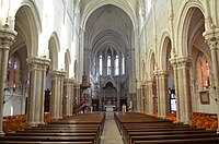
Eglise Saint Martin - Vertou (Loire-Atlantique)
Författare/Upphovsman: Selbymay, Licens: CC BY-SA 3.0
Eglise Saint Martin - Vertou (Loire-Atlantique)
Författare/Upphovsman: Pymouss44, Licens: CC BY-SA 3.0
Lerat fountain in Vertou
Författare/Upphovsman: Selbymay, Licens: CC BY-SA 3.0
Det här byggnadsverket är inskrivet som historiskt monument (inscrit Monument Historique) i Frankrike. Det finns med i base Mérimée, Frankrikes kulturministeriums databas över den franska arkitekturens kulturarv, under referensen PA00108840
Blason non-officiel attendu que ce département ne revendique pas de blason) du département de la Loire-Atlantique.
Bonjour,

Pour faire suite à votre mail du 27 juillet dernier, voici quelques éléments
concernant les "armoiries" du département de Loire-Atlantique.

Les "armoiries" où figurent les blasons des quatre sous-préfectures de L-A sont
en fait un insigne remis jadis à chaque conseiller général dans l'Entre-Deux-Guerres
(la sous-préfecture de Paimboeuf a été supprimée en 1926). Il ne s'agit donc pas à
proprement parler d'armoiries du département. Je crois que le port de cet insigne a
persisté jusque dans les années 1950.
La République ne reconnaît plus les armoiries (ni les blasons). Chacun est libre de
s'en créer, dans la mesure où elles respectent les règles de l'héraldique. On ne peut
dans ces conditions dire que chaque département ou chaque ville possède des
"armoiries" officielles.

Cordialement, DEROUET Danielle
Författare/Upphovsman: Selbymay, Licens: CC BY-SA 3.0
Eglise Saint Martin - Vertou (Loire-Atlantique)
Författare/Upphovsman: Pymouss44, Licens: CC BY-SA 3.0
Portillon castle in Vertou
Författare/Upphovsman: Michiel1972, Licens: CC BY-SA 3.0
Population - Municipality code 44215.svg
Population Census 1962-2008


