Vallon-Pont-d'Arc
| Vallon-Pont-d'Arc | ||
| Kommun | ||
 | ||
| ||
| Land | ||
|---|---|---|
| Region | Auvergne-Rhône-Alpes | |
| Departement | ||
| Arrondissement | Largentière | |
| Kanton | Vallon-Pont-d'Arc | |
| Koordinater | 44°24′N 4°24′Ö / 44.400°N 4.400°Ö | |
| Yta | 28,62 km²[1] | |
| Folkmängd | 2 469 ()[2] | |
| Befolkningstäthet | 86 invånare/km² | |
| Tidszon | CET (UTC+1) | |
| - sommartid | CEST (UTC+2) | |
| Postnummer | 07150 | |
| INSEE | 07330 | |
| Geonames | 2970885 | |
| OSM-karta | 272080 | |
 Kommunens läge i regionen Auvergne-Rhône-Alpes i Frankrike. | ||
| Webbplats: http://www.mairie-vallon.com | ||

Vallon-Pont-d'Arc är en kommun i departementet Ardèche i regionen Auvergne-Rhône-Alpes i sydöstra Frankrike. Kommunen ligger i kantonen Vallon-Pont-d'Arc som ligger i arrondissementet Largentière. År 2022 hade Vallon-Pont-d'Arc 2 469 invånare.
Befolkningsutveckling
Antalet invånare i kommunen Vallon-Pont-d'Arc
Referens: INSEE[3]
Galleri
 Grottmålning daterad med C-14 till 29 000 f.Kr.
 Grottmålning

Se även
Källor
- ^ Répertoire géographique des communes, Institut national de l'information géographique et forestière, läst: 26 oktober 2015.[källa från Wikidata]
- ^ Populations légales 2022, Institut National de la Statistique et des Études Économiques, 19 december 2024.[källa från Wikidata]
- ^ Chiffres clés - Évolution et structure de la population Arkiverad 5 juli 2012 hämtat från the Wayback Machine.
Media som används på denna webbplats

Författare/Upphovsman: Eric Gaba (Sting - fr:Sting), Licens: CC BY-SA 4.0
Blank physical map of metropolitan France for geo-location purpose.
Scale : 1:14 816 000 (accuracy : about 3,7 km) for the bathymetry. More maps of France, view → Commons Atlas of France.

Shiny red button/marker widget. Used to mark the location of something such as a tourist attraction.

Blason de l'ancien pays du Vivarais (Languedoc) : d'azur semé de fleurs de lys d'or à la bordure du même chargée de huit écussons aussi d'azur
Författare/Upphovsman: The original uploader was Vpe på franska Wikipedia., Licens: CC BY-SA 2.0 fr
Le Pont d'Arc en Ardèche, début des gorges de l'Ardèche. commune de fr:Vallon-Pont-d'Arc.
Photo prise par alain@souleliac.fr pour le site http://www.aventure-canoes.fr en mai 2005.
photographie personnelle, si vous voulez utiliser cette image, merci d'en indiquer la source..svg)
Författare/Upphovsman: unknown, Licens: CC BY-SA 3.0
Författare/Upphovsman:
|
Map data (c) OpenStreetMap contributors, CC-BY-SA _French_municipality_map.svg) • Shape files infrastructure: railway, highways, water: all originally by OpenStreetMap contributors. Status december 2011 *note: shown commune boundaries are from OSM dump May 2012; at that time about 90% complete |
Map commune FR insee code 07330.png


Horses from the Chauvet Cave (31,000 BP)
Place of discovery: Chauvet Cave, Ardèche, France
Date: 31,000 BP (Aurignacian)
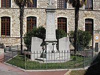
Town Hall of Vallon-Pont-d'Arc, département Ardèche, France