Växjö Maria församling
| Växjö Maria församling Före detta församling | |
 | |
| Land | Sverige |
|---|---|
| Kommun | Växjö kommun |
| Trossamfund | Svenska kyrkan |
| Stift | Växjö stift |
| Bildad | 1 januari 1995 |
| av del av | Skogslyckans församling |
| Upphörd | 31 december 2013 |
| Uppgått i | Växjö stads- och domkyrkoförsamling |
| Upphov till | Växjö Maria distrikt |
| Karta | |
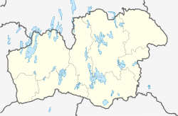
Växjö Maria församlings läge i Kronobergs län. | |
| Koordinat | 56°53′57″N 14°48′04″Ö / 56.899041666667°N 14.801072222222°Ö |
| Utsträckning | SCB:s kartsök |
| Koder, länkar | |
| Församlingskod | 078029 |
| Redigera Wikidata | |
Växjö Maria församling var en församling i Östra Värends kontrakt i Växjö stift inom Svenska kyrkan som var belägen i Växjö i Växjö kommun. Församlingen uppgick 2014 i Växjö stads- och domkyrkoförsamling.
Församlingskyrka var Mariakyrkan.
Administrativ historik
Församlingen bildades 1995 som en utbrytning ur Skogslyckans församling och utgjorde därefter till 2014 ett eget pastorat.[1] Församlingen uppgick 2014 i Växjö stads- och domkyrkoförsamling.[2]
Källor
- ^ ”Församlingar”. Statistiska centralbyrån. https://www.scb.se/hitta-statistik/regional-statistik-och-kartor/regionala-indelningar/forsamlingar/. Läst 30 december 2022.
- ^ ”Församlingar”. Statistiska centralbyrån. https://www.scb.se/hitta-statistik/regional-statistik-och-kartor/regionala-indelningar/forsamlingar/. Läst 30 december 2022.
Media som används på denna webbplats
Shiny red button/marker widget. Used to mark the location of something such as a tourist attraction.
Mariakyrkan i Växjö (Hovshaga), byggd 1979
Författare/Upphovsman: Erik Frohne, Licens: CC BY 3.0
Location map of Kronoberg County in Sweden. N-S stretching is 183%, geographic limits of the map:
- N: 57.30° N
- S: 56.30° N
- W: 13.20° E
- E: 16.00° E


