Upernavik
| Upernavik | |
| Stad | |
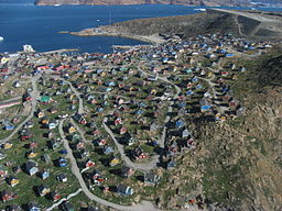
(c) I, Kim Hansen, CC BY-SA 3.0 Flygbild över Upernavik från juli 2007. | |
| Stat | |
|---|---|
| Autonomt land | |
| Kommun | Avannaata |
| Koordinater | 72°47′13″N 56°8′50″V / 72.78694°N 56.14722°V |
| Folkmängd | 1 064 (2024) |
| Tidszon | UTC-3 |
| Postnummer | 3962 |
| Geonames | 3418910 |
Upernavik på kartan över Grönland. | |
Upernavik är en stad i kommunen Avannaata i Grönland. År 2024 hade staden 1 064 invånare.[1]
Belägenhet
Upernavik ligger på en liten ö med samma namn, strax utanför det grönländska fastlandet och ett antal mil norr om den större ön Disko. Staden är centralort i en mycket stor, glesbefolkad arkipelag (Se bild).

Upernavik i kulturen
Upernavik är spelplats för delar av handlingen i Jules Vernes satiriska roman Guldmeteoren (postumt 1908, La chasse au météore; på svenska 1974). Det är på denna lilla ö den eftersökta eldkulan från himmelen till slut slår ner.[2]
Referenser
- ^ ”Population in Localities January 1st 1977-2024”. Statistics Greenland. https://bank.stat.gl/pxweb/en/Greenland/Greenland__BE__BE01__BE0120/BEXSTD.px?rxid=BEXSTD17-04-2024%2012:30:02. Läst 17 april 2024.
- ^ Verne, Jules: Guldmeteoren, Delta Förlags AB, 1974. ISBN 91-7228-266-5
Se även
Externa länkar
 Wikimedia Commons har media som rör Upernavik.
- Greenland.com - Upernavik
- Upernavik.gl - Officiell Webbplats

| ||||||||||
Media som används på denna webbplats
(c) David Newton, CC BY-SA 3.0
The split flag is the official symbol of Denmark and can only be used by state authorities such as the army and the royal family.
Shiny red button/marker widget. Used to mark the location of something such as a tourist attraction.
(c) I, Kim Hansen, CC BY-SA 3.0
Aerial photograph of Upernavik town, Greenland. The photograph was taken from a Bell helicopter approaching Upernavik.
Författare/Upphovsman: Uwe Dedering, Licens: CC BY-SA 3.0
Relief location map of Greenland.
- Projection: EquiDistantConicProjection.
- Area of interest:
- N: 85.0° N
- S: 59.0° N
- W: -75.0° E
- E: -10.0° E
- Projection center:
- NS: 72.0° N
- WE: -42.5° E
- Standard parallels:
- 1: 64.0° N
- 2: 80.0° N
- GMT projection: -JD-42.5/72/64/80/20c
- GMT region: -R-60.16/57.61/24.5/79.91r
- GMT region for grdcut: -R-120.24/57.61/24.5/85.78r
- Relief: SRTM30plus.
- Made with Natural Earth. Free vector and raster map data @ naturalearthdata.com.
Författare/Upphovsman: Algkalv (talk), Licens: CC BY-SA 3.0
Geography of Upernavik Archipelago on the coast of northeastern Baffin Bay, Greenland. Sketch map.
Författare/Upphovsman: Kim Hansen, Licens: CC BY-SA 3.0
Evening panorama of the north-western part of the town Upernavik in Greenland. The viewpoint is a cliff near the soccer field with a south-eastern heading. The image has been generated using Hugin based on 21 individual photos taken at max zoom in two rows. Shutter speed: 1/250 s, aperture: 5.5. Vignetting has been minimized using a best fit polynomial in Hugin. The output image from Hugin has been rectangularly cropped to a pixel height of +1900 followed by a slight increase of lightness and saturation. Hereafter resampled to a pixel height of 1500 using a cubic spline interpolation. Finally, the image was Smart Sharpened using GIMP with a pixel radius of 1.0 and an amount of 1.0.


