Untertilliach
| Untertilliach | |
| Kommun | |
Untertilliach | |
| Land | |
|---|---|
| Förbundsland | Tyrolen |
| Distrikt | Lienz |
| Koordinater | 46°42′13″N 12°40′40″Ö / 46.7036°N 12.6779°Ö |
| Area | 36,34 km²[1] |
| Folkmängd | 216 (1 januari 2024)[2] |
| Befolkningstäthet | 6 invånare/km² |
| Tidszon | CET (UTC+1) |
| - sommartid | CEST (UTC+2) |
| Kommunkod | 70733 |
| Geonames | 2762603 |
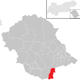
Kommunens läge i distriktet Lienz | |
Untertilliach är en ort och kommun i distriktet Lienz i förbundslandet Tyrolen i Österrike. I söder gränsar kommunen mot Italien.
Källor
- ^ ”Gemeindeverzeichnis 2024” (på tyska) (.ods). Statistik Austria. https://www.statistik.at/fileadmin/pages/453/RegGemVz2024.ods. Läst 20 augusti 2024.
- ^ ”Bevölkerung zu Jahresbeginn nach administrativen Gebietseinheiten (Bundesländer, NUTS-Regionen, Bezirke, Gemeinden) seit 2002” (på tyska) (.ods). Statistik Austria. https://www.statistik.at/fileadmin/pages/405/Bev_Zeitreihe_Jahresbeginn_Gebietseinheiten_2024.ods. Läst 20 augusti 2024.
Media som används på denna webbplats
Författare/Upphovsman: Uwe Dedering, Licens: CC BY-SA 3.0
Location map of Austria
Equirectangular projection, N/S stretching 150 %. Geographic limits of the map:
- N: 49.2° N
- S: 46.3° N
- W: 9.4° E
- E: 17.2° E
Shiny red button/marker widget. Used to mark the location of something such as a tourist attraction.
Författare/Upphovsman: Jürgele, Licens: CC BY-SA 3.0 at
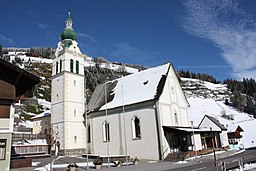
Kath. Pfarrkirche Hll. Florian, Ingenuin und Albuin
Författare/Upphovsman: Joschi Täubler, Licens: CC BY-SA 3.0
District Lienz


