Unionville, Missouri
| Unionville | |
| city | |
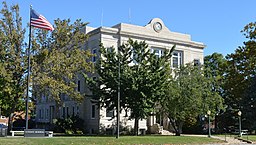
Domstolsbyggnaden | |
| Land | |
|---|---|
| Delstat | Missouri |
| County | Putnam County |
| Höjdläge | 324 m ö.h. |
| Koordinater | 40°28′35″N 93°0′22″V / 40.47639°N 93.00611°V |
| Yta | 5,2 km² (2010) |
| - land | 5,2 km² |
| - vatten | 0,0 km² |
| Folkmängd | 1 865 (2010) |
| Befolkningstäthet | 359 invånare/km² |
| Tidszon | CST (UTC-6) |
| - sommartid | CDT (UTC-5) |
| ZIP-kod | 63565 |
| FIPS | 2975166 |
| Geonames | 5057655 |
Ortens läge i Missouri | |
Missouris läge i USA | |
| Webbplats: http://www.unionvillemo.org/ | |
Unionville är administrativ huvudort i Putnam County i Missouri.[1][2] Countyts territorium utökades år 1854 och den nya geografiska mittpunkten valdes till plats för ny huvudort. Orten hette först Harmony men namnbytet till Unionville skedde redan år 1855.[3]
Källor
- ^ Missouri County Map with County Seat Cities. Geology.com Geoscience News and Information. Läst 6 maj 2016.
- ^ Profile for Unionville, Missouri. ePodunk. Läst 6 maj 2016.
- ^ Putnam County Courthouse. University of Missouri Extension. Läst 6 maj 2016.
|
Media som används på denna webbplats
Författare/Upphovsman: Alexrk2, Licens: CC BY 3.0
Den här Det karta skapades med GeoTools.
Shiny red button/marker widget. Used to mark the location of something such as a tourist attraction.
Författare/Upphovsman: This version: uploader
Base versions this one is derived from: originally created by en:User:Wapcaplet, Licens: CC BY 2.0
Map of USA with Missouri highlighted
Författare/Upphovsman: Kbh3rd, Licens: CC BY 4.0
Putnam County Courthouse in Unionville, Missouri


