Uintah County
- Artikeln behandlar countyt i Utah, ej att förväxla med Uinta County i Wyoming.
| Uintah County | |
| County | |
Fantasy Canyon | |
| Land | |
|---|---|
| Delstat | |
| Huvudort | Vernal |
| Största stad | Vernal |
| Area | 11 659 km² (2010)[1] |
| - land | 11 602 km² (100%) |
| - vatten | 56,2 km² (0%) |
| Folkmängd | 32 588 (2010)[2] |
| Befolkningstäthet | 2,8 invånare/km² |
| Grundat | 1880 |
| Tidszon | MST (UTC-7) |
| - sommartid | MDT (UTC-6) |
| FIPS-kod | 49047 |
| Geonames | 5783919 |
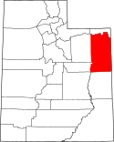
Läge i delstaten Utah. | |
Delstatens läge i USA. | |
| Fotnoter: Naco - Find a county | |
Uintah County är ett administrativt område i delstaten Utah, USA, med 32 588 invånare. Den administrativa huvudorten (county seat) är Vernal.
Del av Dinosaur nationalmonument ligger i countyt.
Geografi
Enligt United States Census Bureau har countyt en total area på 11 652 km². 11 595 km² av den arean är land och 57 km² är vatten.
Angränsande countyn
- Daggett County, Utah - nord
- Moffat County, Colorado nordöst
- Rio Blanco County, Colorado - öst
- Garfield County, Colorado - sydöst
- Grand County, Utah - syd
- Emery County, Utah - sydväst
- Carbon County, Utah - väst
- Duchesne County, Utah - väst
- Summit County, Utah - nordväst
Källor
- ^ ”2010 Census U.S. Gazetteer Files for Counties”. U.S. Census Bureau. Arkiverad från originalet den 5 juli 2012. https://www.webcitation.org/68vYLbou5?url=http://www.census.gov/geo/www/gazetteer/files/Gaz_counties_national.txt. Läst 5 juli 2012.
- ^ ”State & County QuickFacts, Uintah County, Utah” (på engelska). U.S. Census Bureau. Arkiverad från originalet den 21 juli 2011. https://www.webcitation.org/60LPFYhAb?url=http://quickfacts.census.gov/qfd/states/49/49047.html. Läst 6 juli 2011.
| ||||||||||
Media som används på denna webbplats
The flag of Utah (2024-present). This is the final design submitted for consideration to be adopted as a new state flag of Utah. The design evokes images of snowy mountains and red rocks to represent the geography of Utah, the beehive represents "Industry" (the state's slogan) and Utah's nickname as "the Beehive State".
Författare/Upphovsman: This version: uploader
Base versions this one is derived from: originally created by en:User:Wapcaplet, Licens: CC BY 2.0
Map of USA with Utah highlighted
Författare/Upphovsman: James St. John, Licens: CC BY 2.0
Differentially cemented & eroded sandstone in the Eocene of Fantasy Canyon, Utah, USA.
Fantasy Canyon has the most spectacular examples of differential weathering and differential erosion I've ever seen. The rocks are quartzose sandstones that were deposited on the eastern shore of ancient Lake Uinta, which existed during the Eocene. Some wisps and ribbons of dark-colored, magnetite-rich sand are present in the sandstone. The variety of chaotic rockforms at Fantasy Canyon are quite diverse - these cannot be explained by ordinary weathering and erosion. Close examination shows that erosion has acted upon differentially cemented sandstone. The sandstone has not undergone complete lithification and diagenesis - groundwater lobes have preferentially cemented portions of the sandstone, especially immediately adjacent to joint planes. The poorly-cemented sandstone was easily eroded & the better-cemented sandstone remains.
Stratigraphy: member C, Uinta Formation, Eocene
Locality: Fantasy Canyon, between Red Wash & Coyote Wash, Chapita Wells Gas Field, west-northwest of the town of Bonanza & south-southeast of the town of Vernal & east of the town of Ouray, northeastern Utah, USAThis is a locator map showing Uintah County in Utah. For more information, see Commons:United States county locator maps.


