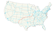
U.S. Route 54
| U.S. Route 54 | |
 | |
 | |
| Längd | 1926 km |
|---|---|
| Byggd | 1926 |
U.S Route 54 (också kallad U.S. Highway 54 eller med förkortningen US 54) är en amerikansk landsväg i USA som sträcker sig i nordväst-sydostlig riktning. Vägen är 1926 km lång och sträcker sig från Griggsville, Illinois i norr till El Paso, Texas i söder. Vägen går igenom Texas två gånger, i El Paso innan vägen går över till delstaten New Mexico och nästa gång i norra Texas mellan delstaterna New Mexico och Oklahoma.
Externa länkar
 Wikimedia Commons har media som rör U.S. Route 54.
| |||||||
Media som används på denna webbplats
600 mm by 600 mm (24 in by 24 in) U.S. Route shield, made to the specifications of the 2004 edition of Standard Highway Signs. (Note that there is a missing "J" label on the left side of the diagram.) Uses the Roadgeek fonts. (United States law does not permit the copyrighting of typeface designs, and the fonts are meant to be copies of a U.S. Government-produced work anyway.)
600 mm × 600 mm (24 in × 24 in) U.S. Highway shield, made to the specifications of the 2004 edition of Standard Highway Signs. (Note that there is a missing "J" label on the left side of the diagram.) Uses the Roadgeek 2005 fonts. (United States law does not permit the copyrighting of typeface designs, and the fonts are meant to be copies of a U.S. Government-produced work anyway.)


