Tyne
| Tyne | |
| Flod | |
Tyne i Newcastle upon Tyne | |
| Land | |
|---|---|
| Riksdel | England |
| Bifloder | |
| - vänster | River Derwent |
| Källa | North Tyne och South Tynes sammanflöde |
| - läge | Hexham, Northumberland |
| - koordinater | 54°59′20″N 02°07′49″V / 54.98889°N 2.13028°V |
| Mynning | |
| - läge | Nordsjön vid Tynemouth, Tyne and Wear |
| - höjdläge | 0 m ö.h. |
| - koordinater | 55°00′37″N 01°25′08″V / 55.01028°N 1.41889°V |
| Längd | 100[1] km |
| Flodbäcken | 2 933 km² |
| Vattenföring | |
| - medel | 44,6 m³/s |
| Geonames | 2635276 |
Floder i England | |
Tyne är en flod i England. Den består av floderna North Tyne och South Tyne som rinner samman nära Hexham i Northumberland.[1] South Tyne har sin källa i Alston Moor i Cumbria, medan North Tyne har sin källa vid den skotska gränsen. Efter att floderna flutit samman passerar Tyne bland annat Corbridge, Blaydon och Newcastle upon Tyne. Från 1200-talet och fram till 1900-talet var Tyne en viktig transportled för kol. Tynes avrinningsområde är 2 933 km².
Korsande broar och tunnlar
Tynefloden

| Namn | Trafik | Öppnad |
|---|---|---|
| Shields Ferry | Fotgängare och cyklister | 1377[2] |
| Second Tyne vehicle tunnel | A19 road | 25 feb 2011 |
| First Tyne vehicle tunnel | A19 road | 19 okt 1967 |
| Tyne pedestrian and cyclist tunnel | Gångväg, cykelfält | 24 jul 1951 |
| Millenniumbron | Gångväg | 2000 |
| Tyne Bridge | A167 | 10 okt 1928 |
| Swing Bridge | Oklassificerad väg | 15 jun 1876 |
| High Level Bridge | Durham Coast Line, East Coast Main Line, B1307 road | 27 sep 1849 |
| Queen Elizabeth II Metro Bridge | Newcastles tunnelbana | 1981 |
| King Edward VII Bridge | East Coast Main Line | 10 jul 1906 |
| Redheugh Bridge | A189 road | 18 maj 1983 |
| Scotswood Bridge | A695 road | 1964 |
| Scotswood Railway Bridge | Tyne Valley line, Rörledning | 1871 |
| Blaydon Bridge | A1 | 3 dec 1990 |
| Newburn Bridge | Oklassificerad väg | 1893 |
| Wylam Bridge | Oklassificerad väg | 1836 |
| Wylam Railway Bridge | Scotswood, Newburn and Wylam Railway, National Cycle Route 72 | 6 okt 1876 |
| Ovingham footbridge | Gångväg, National Cycle Route 72 | 1974[3] |
| Ovingham road bridge | Oklassificerad väg | 20 dec 1883[3] |
| Bywell Bridge | B6309 road | 1838 |
| Styford Bridge | A68 road[4] | 1979 |
| Corbridge Bridge | B6321 road | 1674[5] |
| Hexham Bridge | A6079 road, National Cycle Route 72 | 1793[5] |
| Hexham Old Bridge | Väg | 1770[5] |
| Border Counties Bridge | Border Counties Railway | 1856 |
| Constantius Bridge | A69 road | 1976 |
Norra Tynefloden
| Namn | Trafik | Öppnad |
|---|---|---|
| Chesters Roman bridge | Romerska militärvägen söder om Hadrianus mur | 122 |
| Chollerford Bridge | Militärvägen i Northumberland | 1785 |
| Wark Bridge | Oklassificerad väg | 1878 |
| Bellingham Bridge | B6320 road | 1834 |
| Tarset Bridge | Oklassificerad väg | 1974 |
| Greystead Bridge | Gångväg | 1862 |
| Falstone Bridge | Oklassificerad väg | 1843 |
| Kielder Viaduct | Border Counties Railway, Lakeside Way | 1862 |
| Butteryhaugh Bridge | Oklassificerad väg | 1962 |
| Kerseycleugh Bridge | Oklassificerad väg | 1853 |
Södra Tynefloden
| Namn | Trafik | Öppnad |
|---|---|---|
| Warden Railway Bridge | Tyne Valley line | 1904 |
| Warden Bridge | Oklassificerad väg | Nov 1903 |
| New Haydon Bridge | A686 road | 1970 |
| Old Haydon Bridge | Gångväg | 1776 |
| Haydon Bridge Viaduct | A69 road | 25 mar 2009 |
| Lipwood Railway Bridge | Tyne Valley line | 1866 |
| Ridley Bridge | Oklassificerad väg | 1792 |
| Ridley Railway Bridge | Tyne Valley line | 1907 |
| Millhouse Bridge | Gångväg | 1883 |
| Haltwhistle A69 Bridge (East) | A69 road | 1994 |
| Alston Arches Viaduct | Alston Line, gångväg | 17 nov 1852 |
| Blue Bridge | Pennine Cycleway, gångväg | 1875 |
| Bellister Bridge | Gångväg | 1967 |
| Haltwhistle A69 Bridge (West) | A69 road | 1997 |
| Featherstone Bridge | Oklassificerad väg | 1775 |
| Featherstone Castle Footbridge | Gångväg | 1990 |
| Diamond Oak Bridge | Oklassificerad väg | 1975 |
| Lambley Footbridge | Gångväg | 1992 |
| Lambley Viaduct | Alston Line, gångväg | 1852 |
| Eals footbridge | Gångväg | 1961[3] |
| Eals Bridge | Oklassificerad väg | 1733 |
| Parson Shields bridge | Landsväg | 1972[3] |
| Williamston Bridge | Oklassificerad väg | |
| Kirkhaugh footbridge | Gångväg | |
| Alston railway bridge | Alston Line, South Tyne Trail, South Tynedale Railway[6] | 1852 |
| Alston bridge | A686 road | 1836 |
| Garrigill Bridge | Oklassificerad väg |
Referenser
- ^ [a b] ”River Tyne | river, England, United Kingdom” (på engelska). Encyclopedia Britannica. https://www.britannica.com/place/River-Tyne. Läst 4 augusti 2019.
- ^ https://www.shieldsgazette.com/news/ferry-gets-first-woman-boss-in-700-years-1-1295528
- ^ [a b c d] Bridges On The Tyne, 2006, Wikidata Q105064675, https://www.bridgesonthetyne.co.uk/
- ^ https://explore.osmaps.com/pin?lat=54.951476&lon=-1.952702&zoom=13.0000&style=Standard&type=2d
- ^ [a b c] Frank Graham (1992) (på engelska). Hexham and Corbridge: A Short History and Guide. Thropton: Butler Publishing. Wikidata Q105036820. ISBN 0-946928-19-3.
- ^ https://www.south-tynedale-railway.org.uk/preservation-2/
Externa länkar
 Wikimedia Commons har media som rör Tyne.
Media som används på denna webbplats
(c) OOjs UI Team and other contributors, MIT
An icon from the OOjs UI MediaWiki lib.
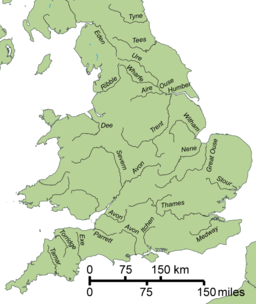
A variant of Image:Gb4dot_rivers.svg, indicating the rivers of England only.
(c) Peter McDermott, CC BY-SA 2.0
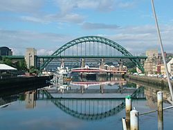
River Tyne View looking along Newcastle Quayside from the Tyne Bridge.
Författare/Upphovsman: The original uploader was Steve nova på engelska Wikipedia., Licens: CC BY-SA 3.0
upload my own photograph
Författare/Upphovsman: Tagishsimon, Licens: CC BY-SA 3.0
The Tyne Bridge across the River Tyne between Newcastle upon Tyne and Gateshead. Taken from the deck of the Gateshead Millennium Bridge, looking west.
The Tyne Bridge is the compression arch bridge in green. Below and behind it is the Swing Bridge, in red. Behind that, in grey, is the High Level Bridge. Behind that is the w:Queen Elizabeth II Metro Bridge. You can just about see the pillars of the King Edward VII Bridge, which carries the mainline railway across the river into Newcastle Central station; and, I assure you, the Redheugh Bridge (a modern road bridge) is hidden behind them all.
The boats on the Gateshead shore are the Archer class patrol vessels of the HMS Calliope shore establishment, and the permanently moored Tuxedo Princess floating nightclub (the former car ferry TSS Caledonian Princess).
This photo appears to have been taken from the Tyne's easternmost bridge, the low-level, swivelling, pedestrian Millenium Bridge.


