Tropiska cyklonen Nargis
Kategori 4-cyklon (SSO) | |
 Nargis den 1 maj | |
| Formation | 27 april 2008 |
|---|---|
| Avmattning | 3 maj 2008 |
| Kraftigaste vindar | |
| Lägsta lufttryck | 962 mbar (hPa; 722 mmHg) |
| Döda | minst 138 000 döda eller saknade [1][2] |
| Skador | 10 miljarder USD[3] |
| Drabbade områden | Bangladesh, Indien, Myanmar, Sri Lanka |
Den mycket kraftiga cyklonen Nargis var den första tropiska cyklonen i den Indiska orkansäsongen 2008.
Stormhistoria

Ett oroligt väderområde bildades först öster om Nikobarerna den 24 april. Det började sakta att röra sig i nordvästlig riktning, in i ett område med låga vertikala vindar. Man rapporterade att systemet började formas den 25 april.[4] Den 27 april uppgraderade man systemet till en depression[5], och nästa dag uppgraderades den till den cykloniska stormen Nargis.[6] Några timmar senare uppgraderades den till en kraftig cyklon. Nästa dag fick den status som en mycket kraftig cyklon.
Efter att Nargis nått land försvagades den mycket snabbt innan den helt avmattades.
Skador

Burma
Nargis orsakade stora skador i Myanmar. I största staden Rangoon skadades flera byggnader och många delar av staden är utan ström och telefoni. [7] De värst drabbade områdena är området runt floden Irrawaddy där uppemot all bebyggelse ska ha förstörts.[8][7]
Antalet döda och saknade i Myanmar som följd av cyklonen beräknas vara över 138 000, där de officiella siffrorna anger antalet döda till 84 537 och 53 836 saknade.[2]
Övriga länder
I Sri Lanka producerade cyklonen kraftiga regnfall, vilket ledde till översvämningar och jordskred i tio av Sri Lankas distrikt.[9] Omkring 35 000 har drabbats av cyklonen.[10] Tre personer rapporterades skadade, och två andra döda. [9]
Källor
- ^ 700.000 burmesiska barn i nöd, svt.se, 25 juli 2008
- ^ [a b] Myanmar cyclone toll rises to 138,000 dead, missing, Reuters UK, 24 juni 2008
- ^ Asian bloc to handle Burma aid, Toronto Star, 19 maj 2008
- ^ SIGNIFICANT TROPICAL WEATHER ADVISORY FOR THE INDIAN OCEAN
- ^ ”Depression over southeast Bay of Bengal”. Arkiverad från originalet den 30 januari 2009. https://web.archive.org/web/20090130110745/http://imd.gov.in/section/nhac/dynamic/cwind.htm. Läst 27 april 2008.
- ^ ”Cyclonic storm “NARGIS” over southwest and adjoining southeast and westcentral Bay of Bengal”. Arkiverad från originalet den 6 maj 2008. https://web.archive.org/web/20080506025105/http://www.imd.ernet.in/section/nhac/dynamic/cwind.htm. Läst 28 april 2008.
- ^ [a b] cnn.com - Cyclone hits Myanmar's capital, damages homes
- ^ dn.se - Dödsoffer vid cyklon i Burma
- ^ [a b] Daily Mirror (30 april 2008). ”Floods leave thousands homeless”. Arkiverad från originalet den 9 maj 2008. https://web.archive.org/web/20080509041021/http://www.dailymirror.lk/DM_BLOG/Sections/frmNewsDetailView.aspx?ARTID=13275. Läst 3 maj 2008.
- ^ Lakshmi de Silva (30 april 2008). ”Over 35,000 affected by floods, landslides”. Upali Newspapers Limited. Arkiverad från originalet den 9 maj 2008. https://web.archive.org/web/20080509024830/http://www.island.lk/2008/04/30/news2.html. Läst 3 maj 2008.
Media som används på denna webbplats
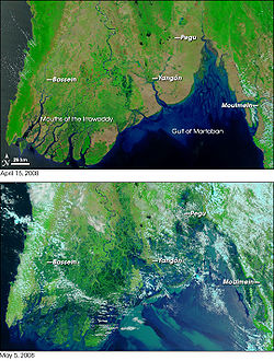
Satellite photos from NASA's w:Terra satellite, showing part of w:Burma/(Myanmar) on April 15, 2008 (top) and May 5, 2008 (bottom), resulting in before-and-after comparisons of the impact from w:Cyclone Nargis.
The first cyclone of the 2008 season in the northern Indian Ocean was a devastating one for Myanmar (Burma). According to reports from Accuweather.com, Cyclone Nargis made landfall with sustained winds of 130 mph and gusts of 150-160 mph, which is the equivalent of a strong Category 3 or minimal Category 4 hurricane. News reports stated that at least 10,000 people were killed, and thousands more were missing as of May 5.
Flood water can be difficult to see in photo-like satellite images, particularly when the water is muddy. This pair of images from the Moderate Resolution Imaging Spectroradiometer (MODIS) on NASA’s Terra satellite use a combination of visible and infrared light to make floodwaters obvious. Water is blue or nearly black, vegetation is bright green, bare ground is tan, and clouds are white or light blue.
On April 15 (top), rivers and lakes are sharply defined against a backdrop of vegetation and fallow agricultural land. The Irrawaddy River flows south through the left-hand side of the image, splitting into numerous distributaries known as the Mouths of the Irrawaddy. The wetlands near the shore are a deep blue green. Cyclone Nargis came ashore across the Mouths of the Irrawaddy and followed the coastline northeast. The entire coastal plain is flooded in the May 5 image (bottom). The fallow agricultural areas appear to have been especially hard hit. For example, Yangôn (population over 4 million) is almost completely surrounded by floods. Several large cities (population 100,000–500,000) are in the affected area. Muddy runoff colors the Gulf of Martaban turquoise.
The high-resolution image provided above is at MODIS’ maximum spatial resolution (level of detail) of 250 meters per pixel. The MODIS Rapid Response Team provides twice-daily images of the region in additional resolutions and formats, including photo-like natural color.
NASA images courtesy the MODIS Rapid Response Team. Caption by Rebecca Lindsey.
References:
- BBC. (2008, May 5). Burma’s storm toll ‘nears 4,000.’ Accessed May 5, 2008.
- Washburn, D. (2008, May 2). Powerful Cyclone Nargis Slams Myanmar. Accuweather.com. Accessed May 5, 2008.
- Unisys. (2008). Cyclone Nargis, Individual Summary. 2008 Hurricane/Tropical Data for Northern Indian Ocean. Accessed May 5, 2008.
Track map of Extremely Severe Cyclonic Storm Nargis of the 2008 North Indian Ocean cyclone season. The points show the location of the storm at 6-hour intervals. The colour represents the storm's maximum sustained wind speeds as classified in the (see below), and the shape of the data points represent the nature of the storm, according to the legend below.
Storm type
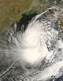
Very Severe Cyclonic Storm Nargis, seen from MODIS on the Terra satellite at 0440Z May 1.


