Tréguier
| Tréguier | ||
| Kommun | ||
 Stadshuset (Hôtel de ville) | ||
| ||
| Land | ||
|---|---|---|
| Region | ||
| Departement | ||
| Arrondissement | Lannion | |
| Kanton | Tréguier | |
| Koordinater | 48°47′N 3°14′V / 48.783°N 3.233°V | |
| Yta | 1,52 km²[1] | |
| Folkmängd | 2 409 ()[2] | |
| Befolkningstäthet | 1 585 invånare/km² | |
| Tidszon | CET (UTC+1) | |
| - sommartid | CEST (UTC+2) | |
| Postnummer | 22220 | |
| INSEE | 22362 | |
| Geonames | 2971929 | |
| OSM-karta | 410107 | |
 Kommunens läge i regionen Bretagne i Frankrike | ||
| Webbplats: http://www.ville-treguier.fr | ||
.svg)

Tréguier är en stad och kommun i departementet Côtes-d'Armor i regionen Bretagne i nordvästra Frankrike. Kommunen ligger i kantonen Tréguier som tillhör arrondissementet Lannion. Staden härstammar från 500-talet. År 2021 hade Tréguier 2 409 invånare.
Filosofen Ernest Renan kom från Tréguier. I kommunen finns ett museum tillägnat honom.
Befolkningsutveckling
Antalet invånare i kommunen Tréguier
Referens:INSEE[3]
Galleri


 Ernest Renan-museet
Se även
Källor
- ^ Répertoire géographique des communes, Institut national de l'information géographique et forestière, läst: 26 oktober 2015, licens: öppen licens.[källa från Wikidata]
- ^ Populations légales 2021, Institut National de la Statistique et des Études Économiques, 28 december 2023.[källa från Wikidata]
- ^ Chiffres clés - Évolution et structure de la population Arkiverad 5 juli 2012 hämtat från the Wayback Machine.
Externa länkar
- Officiell webbplats
 Wikimedia Commons har media som rör Tréguier.
Media som används på denna webbplats

Författare/Upphovsman: Eric Gaba (Sting - fr:Sting), Licens: CC BY-SA 4.0
Blank physical map of metropolitan France for geo-location purpose.
Scale : 1:14 816 000 (accuracy : about 3,7 km) for the bathymetry. More maps of France, view → Commons Atlas of France.

Shiny red button/marker widget. Used to mark the location of something such as a tourist attraction.
Författare/Upphovsman:
|
Map data (c) OpenStreetMap contributors, CC-BY-SA _French_municipality_map.svg) • Shape files infrastructure: railway, highways, water: all originally by OpenStreetMap contributors. Status december 2011 *note: shown commune boundaries are from OSM dump May 2012; at that time about 90% complete |
Map commune FR insee code 22362.png

Town Hall of Treguier (Côtes d'Armor Brittany),

Författare/Upphovsman: Moreau.henri, Licens: CC BY-SA 3.0
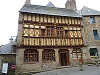
Tréguier: maisons anciennes à pans de bois


Författare/Upphovsman: Moreau.henri, Licens: CC BY-SA 4.0
Tréguier : maison d'Ernest Renan, façade avant