Tokushima
| Tokushima (徳島市) | |
| Stad | |
| Land | |
|---|---|
| Region | Shikoku |
| Prefektur | Tokushima |
| Ö | Shikoku |
| Koordinater | 34°04′N 134°33′Ö / 34.067°N 134.550°Ö |
| Area | 191,23 km²[1] |
| Folkmängd | 261 257 (31 mars 2007)[2] |
| Befolkningstäthet | 1 366 invånare/km² |
| Borgmästare | Sawako Naitō (2020–) |
| Geonames | 1850156 |
| Träd | Elaeocarpus sylvestris[3] |
| Blomma | Japanskt körsbär[3] |
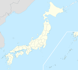
 Tokushimas läge i Japan | |
 Tokushimas läge i prefekturen Tokushima. | |
| Webbplats: http://www.city.tokushima.tokushima.jp/ | |
Tokushima (徳島市, Tokushima-shi) är en stad på östra delen av ön Shikoku i Japan, tillika residensstad i Tokushima prefektur. Den är belägen i prefekturens nordöstra del, vid floden Yoshinos mynning i havet. Staden hade 261 257 invånare år 2007[2] och en yta på 191,23 km²[1]. Orten fick stadsrättigheter den 1 oktober 1889.
Sport
Tokushima Vortis spelar i J-League i professionell fotboll.[4]
Källor
- ^ [a b] ”Statistic Information” (på engelska). Tokushima stad. Arkiverad från originalet den 6 maj 2009. https://web.archive.org/web/20090506012949/http://www.city.tokushima.tokushima.jp/english/statistic.html. Läst 15 maj 2009.
- ^ [a b] Statistical Research and Training Institute, red. ”2 Population and Households” (på japanska/engelska). Japan Statistical Yearbook 2009. Japan Statistics Bureau. http://www.stat.go.jp/english/data/nenkan/1431-02.htm. Läst 15 maj 2009
- ^ [a b] läs online, www.city.tokushima.tokushima.jp .[källa från Wikidata]
- ^ ”2008 J.LEAGUE CLUBS”. Japan Professional Football League. Arkiverad från originalet den 29 april 2009. https://web.archive.org/web/20090429133122/http://www.j-league.or.jp/eng/clubprofile/j2.html. Läst 5 december 2008.
Media som används på denna webbplats
Författare/Upphovsman: Maximilian Dörrbecker (Chumwa), Licens: CC BY-SA 3.0
Location map of Japan
Equirectangular projection.
Geographic limits to locate objects in the main map with the main islands:
- N: 45°51'37" N (45.86°N)
- S: 30°01'13" N (30.02°N)
- W: 128°14'24" E (128.24°E)
- E: 149°16'13" E (149.27°E)
Geographic limits to locate objects in the side map with the Ryukyu Islands:
- N: 39°32'25" N (39.54°N)
- S: 23°42'36" N (23.71°N)
- W: 110°25'49" E (110.43°E)
- E: 131°26'25" E (131.44°E)
Shiny red button/marker widget. Used to mark the location of something such as a tourist attraction.
Map of Tokushima Prefecture highlighting Tokushima city. Borders of map as of October, 2006. (blank map used from [1])
See also Image:TokushimaMapCurrent.png


