Tippah County
| Tippah County | |
| County | |
| Land | |
|---|---|
| Delstat | |
| Huvudort | Ripley |
| Största stad | Ripley |
| Area | 1 191 km² (2010)[1] |
| - land | 1 186 km² (100%) |
| - vatten | 5,5 km² (0%) |
| Folkmängd | 22 232 (2010)[2] |
| Befolkningstäthet | 19 invånare/km² |
| Grundat | 1836 |
| Tidszon | CST (UTC-6) |
| - sommartid | CDT (UTC-5) |
| FIPS-kod | 28139 |
| Geonames | 4448467 |
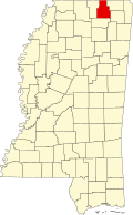
Läge i delstaten Mississippi. | |
Delstatens läge i USA. | |
| Fotnoter: Naco - Find a county | |
Tippah County är ett county i delstaten Mississippi i USA. År 2010 hade countyt 22 232 invånare. Den administrativa huvudorten (county seat) är Ripley.
Geografi
Enligt United States Census Bureau har countyt en total area på 1 191 km². 1 186 km² av den arean är land och 5 km² är vatten.
Angränsande countyn
- Hardeman County, Tennessee - nord
- Alcorn County - nordost
- Prentiss County - sydost
- Union County - syd
- Benton County - väst
Orter
- Dumas
- Ripley (huvudort)
Källor
- ^ ”2010 Census U.S. Gazetteer Files for Counties”. U.S. Census Bureau. Arkiverad från originalet den 5 juli 2012. https://www.webcitation.org/68vYLbou5?url=http://www.census.gov/geo/www/gazetteer/files/Gaz_counties_national.txt. Läst 5 juli 2012.
- ^ ”State & County QuickFacts, Tippah County, Mississippi” (på engelska). U.S. Census Bureau. Arkiverad från originalet den 21 juli 2011. https://www.webcitation.org/60L8UInfp?url=http://quickfacts.census.gov/qfd/states/28/28139.html. Läst 6 juli 2011.
| ||||||||||
|
Media som används på denna webbplats
Författare/Upphovsman: This version: uploader
Base versions this one is derived from: originally created by en:User:Wapcaplet, Licens: CC BY 2.0
Map of USA with Mississippi highlighted
Författare/Upphovsman: Rocky Vaughn, Sue Anna Joe, Dominique Pugh, Clay Moss, Kara Giles, Micah Whitson and the Mississippi Department of Archives and History, Licens: Copyrighted free use
The flag of the U.S. state of Mississippi - aspect ratio of 5:3. Designed in 2020 and adopted in 2021, the "New Magnolia" flag was selected by the Commission to Redesign the Mississippi state flag in 2020.
This is a locator map showing Tippah County in Mississippi. For more information, see Commons:United States county locator maps.
Författare/Upphovsman: Gary Bridgman, Licens: CC-BY-SA-3.0
Bottomland hardwood swamp at the confluence of Tubby Creek and the Wolf River in the Holly Springs National Forest near Ashland, Mississippi.
- The red ribbons [visible in the center of the image] were used for navigation purposes by members of the Wolf River Conservancy in completing the first-ever full descent of the Wolf River in 1998. At the time, this location was considered to be the river's head of navigation, but the canoers had to first discover a way to navigate from the put-in to the actual river channel, located approximately 200 meters to the south. The resulting "path" was marked with the engineer's tape.
- From this point, the Wolf River flows alternately west and north into West Tennessee, joining the Mississippi River in downtown Memphis.


