Tidworth
| Tidworth | |
| Stad | |
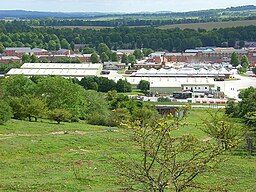
(c) Andrew Smith, CC BY-SA 2.0 Militärgarnison i Tidworth | |
| Land | |
|---|---|
| Riksdel | England |
| Region | Sydvästra England |
| Enhetskommun | Wiltshire |
| Ceremoniellt grevskap | Wiltshire |
| Koordinater | 51°14′41″N 1°39′50″V / 51.24472°N 1.66389°V |
| Area | 3,65 km² (2021)[1] |
| Folkmängd | 10 692 (2021)[2][3] |
| Befolkningstäthet | 2 929 invånare/km² |
| Tidszon | WET (UTC+0) |
| - sommartid | BST (UTC+1) |
| Postort | TIDWORTH |
| Postnummer | SP9 |
| Riktnummer | 01980 |
| Geonames | 2637310 7300368 |
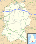
Contains Ordnance Survey data © Crown copyright and database right, CC BY-SA 3.0 Tidworths läge i Wiltshire | |
| Webbplats: www.tidworthtowncouncil.gov.uk | |
Tidworth är en stad och civil parish i grevskapet Wiltshire i södra England. Staden ligger i enhetskommunen Wiltshire, cirka 21,5 kilometer nordost om Salisbury. Tätorten (built-up area) hade 10 692 invånare vid folkräkningen år 2021.[2][3]
Tidworth bestod ursprungligen av de två byarna North Tidworth och South Tidworth.
Referenser
- ^ ”Built Up Areas (2022) GB BGG” (på engelska). geoportal.statistics.gov.uk. Office for National Statistics (ONS). https://geoportal.statistics.gov.uk/datasets/ons::built-up-areas-2022-gb-bgg/about. Läst 9 september 2023.
- ^ [a b] ”Output Area (2021) to Built Up Area to Local Authority District to Region (December 2022) Lookup in England and Wales” (på engelska). geoportal.statistics.gov.uk. Office for National Statistics (ONS). https://geoportal.statistics.gov.uk/datasets/58e34e32a0194f1597d477f5ba93961b_0/about. Läst 9 september 2023.
- ^ [a b] ”Topic Summaries” (på engelska). www.nomisweb.co.uk. Office for National Statistics (ONS). https://www.nomisweb.co.uk/sources/census_2021_ts. Läst 9 september 2023.
Externa länkar
 Wikimedia Commons har media som rör Tidworth.
Media som används på denna webbplats
Shiny red button/marker widget. Used to mark the location of something such as a tourist attraction.
(c) Andrew Smith, CC BY-SA 2.0
Tidworth Camp A view over the garrison from Clarendon Hill.
Contains Ordnance Survey data © Crown copyright and database right, CC BY-SA 3.0
Map of Wiltshire, UK with the following information shown:
- Administrative borders
- Coastline, lakes and rivers
- Roads and railways
- Urban areas
Equirectangular map projection on WGS 84 datum, with N/S stretched 160%
Geographic limits:
- West: 2.40W
- East: 1.35W
- North: 51.72N
- South: 50.92N


