Thermaikos
| Thermaïkós Kólpos (Θεμαϊκός Κόλπος) | |
| Therme Bay, Gulf of Saloníki, Gulf of Salonika, Thermaicus Sinus, Gulf of Thérmai, Gulf of Thessalonike, Gulf of Thermaikos | |
| Bukt | |
| Land | |
|---|---|
| Koordinater | 40°25′18″N 22°44′59″Ö / 40.42165°N 22.74959°Ö |
| Tidszon | EET (UTC+2) |
| - sommartid | EEST (UTC+3) |
| Geonames | 734081 |
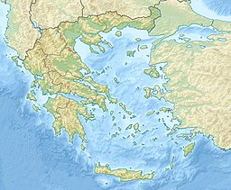
Läge i Grekland | |

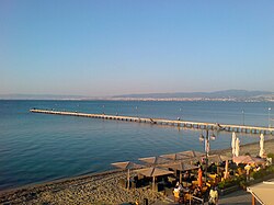
Thermaikosbukten (grekiska: Θερμαϊκός Κόλπος) är en bukt i Egeiska havet på norra Greklands fastland.[1] Den begränsas i öster av halvön Chalkidike. Längs bukten sträcker sig Thessaloniki, Greklands näst största stad med 1 miljon invånare (2004). Saltvatteninträngning i grundvattenakviferer är ett stort problem i området.
Källor
- ^ Thermaïkós Kólpos hos Geonames.org (cc-by); post uppdaterad 2014-03-08; databasdump nerladdad 2015-05-23
Media som används på denna webbplats
Shiny red button/marker widget. Used to mark the location of something such as a tourist attraction.
Författare/Upphovsman: Eftychia Zerde, Licens: CC BY-SA 2.0
Coast line and beach of Perea, Thessaloniki prefecture, Greece. The cities of Thessaloniki and Kalamaria are visible in the background.
Författare/Upphovsman:
- Greece_location_map.svg: Lencer / derivative work: Uwe Dedering (talk)
Location map of Greece


