Tampico, Illinois
| Tampico | |
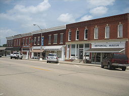
(c) I, IvoShandor, CC BY 2.5 Main Street i Tampico | |
| Land | |
|---|---|
| Delstat | Illinois |
| County | Whiteside County |
| Koordinater | 41°37′50″N 89°47′7″V / 41.63056°N 89.78528°V |
| Yta | 1 km² (2010)[1] |
| - land | 1 km² |
| - vatten | 0 km² |
| Folkmängd | 790 (2010) |
| Befolkningstäthet | 790 invånare/km² |
| Tidszon | CST (UTC-6) |
| - sommartid | CDT (UTC-5) |
| ZIP-kod | 61283[2] |
| FIPS | 1774470 |
| Geonames | 4913209 |
Ortens läge i Illinois | |
Illinois läge i USA | |
Tampico är en liten ort i Illinois, USA med 790 invånare. Orten är mest känd som Ronald Reagans födelseplats.
Källor
- ^ ”2010 Census Gazetteer Files”. US Census Bureau. Arkiverad från originalet den 14 juli 2012. https://www.webcitation.org/699nOulzi?url=http://www.census.gov/geo/www/gazetteer/files/Gaz_places_national.txt. Läst 14 juli 2012.
- ^ ”2010 ZIP Code Tabulation Area (ZCTA) Relationship Files”. U.S. Census Bureau. 29 augusti 2010. Arkiverad från originalet den 25 augusti 2012. https://www.webcitation.org/6ABdwXxbq?url=http://www.census.gov/geo/www/2010census/zcta_rel/zcta_place_rel_10.txt. Läst 25 augusti 2012.
Media som används på denna webbplats
Shiny red button/marker widget. Used to mark the location of something such as a tourist attraction.
(c) I, IvoShandor, CC BY 2.5
Main Street Historic District, Tampico, Illinois. U.S. National Register of Historic Places. National Register Plaque.
(c) I, IvoShandor, CC BY 2.5
Main Street Historic District, Tampico, Illinois. U.S. National Register of Historic Places. 100 block of Main Street (odd numbers).
Författare/Upphovsman: Alexrk2, Licens: CC BY 3.0
Den här Det karta skapades med GeoTools.
Författare/Upphovsman: This version: uploader
Base versions this one is derived from: originally created by en:User:Wapcaplet, Licens: CC BY 2.0
Map of USA with Illinois highlighted


