Tacna, Arizona
| Tacna | |
| CDP | |
| Land | |
|---|---|
| Delstat | |
| County | Yuma County |
| Höjdläge | 107 m ö.h. |
| Koordinater | 32°41′45″N 113°57′47″V / 32.69583°N 113.96306°V |
| Area | 4,98 km² (2010)[1] |
| Folkmängd | 425 (2020)[2] |
| Befolkningstäthet | 85 invånare/km² |
| Tidszon | MST (UTC-7) |
| ZIP-kod | 85352 |
| Riktnummer | 928 |
| GNIS-kod | 2410046 |
| Geonames | 5316761 |
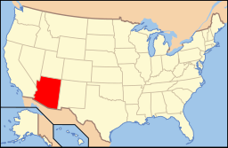
Översiktskarta | |
Arizonas läge i USA | |
| Wikimedia Commons: Tacna, Arizona | |
| Redigera Wikidata | |
Tacna är en ort i Yuma County i delstaten Arizona, USA.
Referenser
- ^ United States Census Bureau, 2010 U.S. Gazetteer Files, United States Census Bureau, 2010, läst: 9 juli 2020.[källa från Wikidata]
- ^ United States Census Bureau (red.), läs online, läst: 1 januari 2022.[källa från Wikidata]
Media som används på denna webbplats
Författare/Upphovsman: Huebi, Licens: CC BY 2.0
Map of USA with Arizona highlighted
This map shows the incorporated areas and unincorporated areas in Yuma County, Arizona. Tacna is highlighted in red. Incorporated cities are shown in gray and unincorporated communities or CDPs are shown in white. Data for the borders and locations are based on maps from the Yuma County DDS Mapping Services, US Census Bureau TIGER Map Server, and ITCA Map of Tribal Homelands in Arizona. I created this map in Inkscape.
Författare/Upphovsman: Heartoftexas1885, Licens: CC0
The post office in Tacna, Arizona. One of the few remaining businesses open in the community.


