Sydvästra England
| Sydvästra England | |
| South West England | |
| Region | |
| Land | |
|---|---|
| Riksdel | England |
| Administrativ huvudort | Bristol |
| Yta | 23 836 km² |
| Folkmängd | 5 764 881 (2022)[1] |
| Befolkningstäthet | 242 invånare/km² |
| Tidszon | GMT (UTC+0) |
| - sommartid | BST (UTC+1) |
| GSS-kod | E12000009 |
| Geonames | 11591956 2637295 |
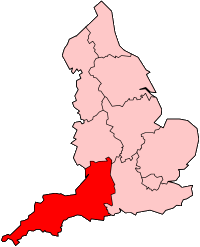
Sydvästra England (eng. South West England) är en av Englands nio regioner. Den består av Cornwall och betydande delar av det historiska Wessex.
Den var en av valkretsarna vid val till Europaparlamentet. Då ingick också, sedan valet 2004, Gibraltar.
 |
|
Se även
Referenser
- ^ ”Estimates of the population for the UK, England, Wales, Scotland, and Northern Ireland (Mid-2022)” (på engelska) (xls). Office for National Statistics. 26 mars 2024. https://www.ons.gov.uk/peoplepopulationandcommunity/populationandmigration/populationestimates/datasets/populationestimatesforukenglandandwalesscotlandandnorthernireland. Läst 25 juni 2024.
| ||||||||||
Media som används på denna webbplats
Flag of England. Saint George's cross (a red cross on a white background), used as the Flag of England, the Italian city of Genoa and various other places.
Författare/Upphovsman:
South_West_England_districts_2011_map.svg: Nilfanion, created using Ordnance Survey data
- English_ceremonial_counties_2010.svg: Nilfanion
- derivative work: Dr Greg and The Equalizer (updated for 2019)
Map of the South West England region, showing its counties and administrative districts. The county colours are the same as those in File:English metropolitan and non-metropolitan counties 2009.svg.
Equirectangular map projection on WGS 84 datum, with N/S stretched 160% Geographic limits:
- West: 6.5W
- East: 1.4W
- North: 52.2N
- South: 49.7N


