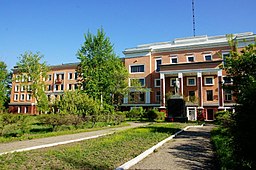
Svobodnyj
| Svobodnyj | |||
| Свобо́дный | |||
| Stad | |||
Järnvägsskolan i Svobodnyj | |||
| |||
| Land | |||
|---|---|---|---|
| Koordinater | 51°22′43″N 128°8′7″Ö / 51.37861°N 128.13528°Ö | ||
| Folkmängd | 55 159 (2015) | ||
| Grundad | 1912 | ||
| Geonames | 2015833 | ||
Svobodnyjs läge i Ryssland | |||
Svobodnyj (ryska: Свобо́дный) är den tredje största staden i Amur oblast i Ryssland. Den ligger vid floden Zeja, cirka 130 kilometer norr om Blagovesjtjensk. Invånarantalet uppgick till 55 159 i början av 2015.[1] Staden grundades 1912 som Aleksejevsk, och fick sitt nuvarande namn 1917.
Källor
- ^ ЧИСЛЕННОСТЬ ПОСТОЯННОГО НАСЕЛЕНИЯ РОССИЙСКОЙ ФЕДЕРАЦИИ ПО МУНИЦИПАЛЬНЫМ ОБРАЗОВАНИЯМ на 1 января 2015 года (komprimerad fil, .rar) Arkiverad 5 november 2021 hämtat från the Wayback Machine. Invånarantal i Rysslands administrativa enheter 1 januari 2015. Läst 7 augusti 2015.
Media som används på denna webbplats
Shiny red button/marker widget. Used to mark the location of something such as a tourist attraction.
Svobodny, Amur oblast, Russia, flag
Författare/Upphovsman: svb28ru, Licens: CC BY-SA 2.0
Жд техникум в г. Свободном
Svobodny (Amur oblast), coat of arms
Författare/Upphovsman: historicair 15:03, 18 September 2007 (UTC), Licens: CC BY-SA 3.0
Russia blank map


