Sutherlin
| Sutherlin | |
| city | |
| Land | |
|---|---|
| Delstat | Oregon |
| County | Douglas County |
| Höjdläge | 160 m ö.h. |
| Koordinater | 43°23′24″N 123°18′45″V / 43.39000°N 123.31250°V |
| Yta | 16 km² (2010) |
| - land | 16 km² |
| - vatten | 0 km² |
| Folkmängd | 7 810 (2010) |
| Befolkningstäthet | 488 invånare/km² |
| Tidszon | PST (UTC-8) |
| - sommartid | PDT (UTC-7) |
| ZIP-kod | 97479 |
| Riktnummer | 541 |
| FIPS | 4171650 |
| Geonames | 5755474 |
Ortens läge i Oregon | |
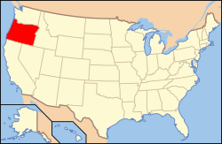
Oregons läge i USA | |
| Webbplats: https://www.ci.sutherlin.or.us/ | |
Sutherlin är en stad i Douglas County i Oregon.[1] Vid 2010 års folkräkning hade Sutherlin 7 810 invånare.[2]
Källor
- ^ Sutherlin, OR. Map Quest. Läst 31 december 2022.
- ^ Census Data for Sutherlin, Oregon. Roadside Thoughts. Läst 31 december 2022.
|
Media som används på denna webbplats
Shiny red button/marker widget. Used to mark the location of something such as a tourist attraction.
Författare/Upphovsman: Huebi, Licens: CC BY 2.0
Map of United States with Oregon highlighted.
(c) Publichall på engelska Wikipedia, CC BY-SA 3.0
The historic Sutherlin Bank Building (built 1910), located at 101 West Central Avenue in Sutherlin, Oregon, United States, is listed on the US National Register of Historic Places (NRHP).
NRHP reference number 84002987
Författare/Upphovsman: Alexrk2, Licens: CC BY 3.0
Den här Det karta skapades med GeoTools.


