Surrey
| Surrey | |||
| Ceremoniellt och administrativt grevskap | |||
| |||
| Land | |||
|---|---|---|---|
| Riksdel | England | ||
| Region | Sydöstra England | ||
| Ingående distrikt | Spelthorne, Runnymede, Surrey Heath, Woking, Elmbridge, Guildford, Waverley, Mole Valley, Epsom and Ewell, Reigate and Banstead, Tandridge | ||
| Administrativ huvudort | Reigate | ||
| Yta | 1 663 km²[1] | ||
| Folkmängd | 1 214 540 (2022)[2] | ||
| Befolkningstäthet | 730 invånare/km² | ||
| Tidszon | GMT (UTC+0) | ||
| - sommartid | BST (UTC+1) | ||
| GSS-kod | E10000030 | ||
| Geonames | 2636512 11609020 | ||
Surrey är ett grevskap i sydöstra England med en yta på 1 663 km2 och med cirka 1,2 miljon invånare (2022). Största ort är Woking. Den norra delen av Surrey består av förorter till London.
Den administrativa huvudorten är sedan 2021 Reigate.
Administrativ indelning
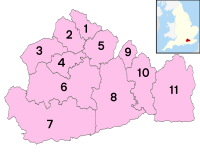
Surrey är dels ett ceremoniellt grevskap (ceremonial county), dels ett administrativt grevskap som är en typ av sekundärkommun (non-metropolitan county). Det administrativa grevskapet är indelat i elva distrikt (non-metropolitan districts), som är en typ av primärkommun.
| Nr | Distrikt | Distrikten i Surrey |
|---|---|---|
| 1 | Spelthorne | |
| 2 | Runnymede | |
| 3 | Surrey Heath | |
| 4 | Woking | |
| 5 | Elmbridge | |
| 6 | Guildford | |
| 7 | Waverley | |
| 8 | Mole Valley | |
| 9 | Epsom and Ewell | |
| 10 | Reigate and Banstead | |
| 11 | Tandridge |
Källor
- ^ ”Estimates of the population for the UK, England, Wales, Scotland, and Northern Ireland (Mid-2022)” (på engelska) (xls). Landyta, avrundad till hela km². Office for National Statistics. 26 mars 2024. https://www.ons.gov.uk/peoplepopulationandcommunity/populationandmigration/populationestimates/datasets/populationestimatesforukenglandandwalesscotlandandnorthernireland. Läst 25 juni 2024.
- ^ ”Estimates of the population for the UK, England, Wales, Scotland, and Northern Ireland (Mid-2022)” (på engelska) (xls). Office for National Statistics. 26 mars 2024. https://www.ons.gov.uk/peoplepopulationandcommunity/populationandmigration/populationestimates/datasets/populationestimatesforukenglandandwalesscotlandandnorthernireland. Läst 25 juni 2024.
Media som används på denna webbplats
Vector Drawing of the "Escut de Surrey"
Författare/Upphovsman: Blake-, Licens: CC BY-SA 4.0
New county flag for Surrey, adopted on 11th September 2014. Gold and blue checks derived from the arms of William de Warenne, 1st Earl of Surrey.
Författare/Upphovsman: Arriva436, Licens: CC BY 3.0
The sign at the entrance to Ladymead park and ride, Guildford, Surrey, for park and ride service 101 to and from Guildford town centre. The park and ride runs on Saturdays only from the car park of the offices of Allianz-Cornhill. Nearby Spectrum park and ride (route 100) runs from the Spectrum Leisure Centre car park, and - being a leisure centre - on Saturdays this car park is busy so instead the service runs from Ladymead instead (though route 100 does run on Saturdays too, just with normal Arriva liveried buses and providing a service for leisure centre visitors).
Författare/Upphovsman: Nilfanion, Licens: CC BY-SA 3.0
Location of the ceremonial county of Surrey within England.
(c) Nilfanion, CC BY 3.0
Numbered districts of Surrey county. Derived from File:Surrey UK district map (blank).svg, by Nilfanion.


