Surprise
- För andra betydelser, se Surprise (olika betydelser).
| Surprise | |
| Stad (city) | |
| Land | |
|---|---|
| Delstat | |
| County | Maricopa County |
| Höjdläge | 358 m ö.h. |
| Koordinater | 33°37′45″N 112°22′4″V / 33.62917°N 112.36778°V |
| Area | 274,2 km² (2010)[3] |
| Folkmängd | 143 148 (2020)[4] |
| Befolkningstäthet | 522 invånare/km² |
| Grundad | 1937[1] |
| Borgmästare | Skip Hall[2] |
| Tidszon | MST (UTC-7) |
| Riktnummer | 623 |
| GNIS-kod | 2412016 |
| Geonames | 5316428 |
Översiktskarta | |
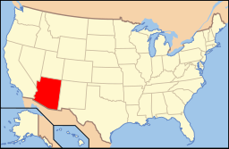
Arizonas läge i USA | |
| Wikimedia Commons: Surprise, Arizona | |
| Webbplats: http://www.surpriseaz.gov/ | |
| Redigera Wikidata | |
Surprise är en stad i centrala Arizona med en yta av 274 km² och en befolkning på 143 000 invånare (2020). Det är en förstad till Phoenix.
Källor
- ^ hämtat från: franskspråkiga Wikipedia.[källa från Wikidata]
- ^ läs online, mayor.surpriseaz.gov , läst: 12 maj 2022.[källa från Wikidata]
- ^ United States Census Bureau, 2010 U.S. Gazetteer Files, United States Census Bureau, 2010, läst: 9 juli 2020.[källa från Wikidata]
- ^ United States Census Bureau (red.), läs online, läst: 1 januari 2022.[källa från Wikidata]
| ||||||||||
Media som används på denna webbplats
Författare/Upphovsman: Huebi, Licens: CC BY 2.0
Map of USA with Arizona highlighted
This map shows the incorporated areas and Indian reservation boundaries in Maricopa County, Arizona, along with water bodies and major highways and roads. Surprise is highlighted in red. Other incorporated cities are shown in gray, planning area borders for these cities and Indian reservation borders are shown as solid black lines. Changes from Previous Version: Updated the maps to include water bodies and to make "less boring" than the plain black/white/gray maps. Format was updated to match standards laid out by WikiProject Maps/Conventions. Map data is based on data from the following Webpage: Maricopa County Interactive GIS Map. I created this map in Inkscape.
Författare/Upphovsman: Venske, Licens: CC BY-SA 3.0
The image represents the new City Hall of the City of Surprise, Arizona, the United States of America. All the buildings, as the entire absolutely new Civic Center of the City of Surprise, were dedicated in October 2009.


