Sturgis, South Dakota
| Sturgis | |
| stad | |
| Land | |
|---|---|
| Delstat | South Dakota |
| County | Meade County |
| Höjdläge | 1 043 m ö.h. |
| Koordinater | 44°24′35″N 103°30′33″V / 44.40972°N 103.50917°V |
| Yta | 10,3 km² (2010) |
| - land | 10,3 km² |
| - vatten | 0,0 km² |
| Folkmängd | 7 020 (2020)[1] |
| Befolkningstäthet | 682 invånare/km² |
| Tidszon | MST (UTC-7) |
| - sommartid | MDT (UTC-6) |
| ZIP-kod | 57785 |
| Riktnummer | 605 |
| FIPS | 4662100 |
| Geonames | 5769489 |
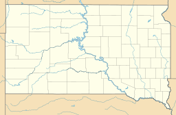
Ortens läge i South Dakota | |
South Dakotas läge i USA | |
| Webbplats: sturgis-sd.gov | |
Sturgis är administrativ huvudort i Meade County i South Dakota.[2][3][4] Enligt 2020 års folkräkning hade Sturgis 7 020 invånare.[1]
Sturgis Motorcycle Rally hålls årligen i början av augusti i Sturgis.[5]
Källor
- ^ [a b] ”Sturgis city; South Dakota 2020 Decennial Census” (på engelska). United States Census Bureau. https://data.census.gov/profile/Sturgis_city,_South_Dakota?g=160XX00US4662100. Läst 21 april 2023.
- ^ South Dakota County Map with County Seat Cities. Geology.com Geoscience News and Information. Läst 20 juni 2017.
- ^ Sturgis, SD. Map Quest. Läst 20 juni 2017.
- ^ Profile for Sturgis, South Dakota Arkiverad 23 juni 2017 hämtat från the Wayback Machine.. ePodunk. Läst 20 juni 2017.
- ^ Sturgis Motorcycle Rally. Travel South Dakota. Läst 20 juni 2017.
|
Media som används på denna webbplats
Shiny red button/marker widget. Used to mark the location of something such as a tourist attraction.
Författare/Upphovsman: Huebi, Licens: CC BY 2.0
Map of USA with South Dakota highlighted
Författare/Upphovsman: Alexrk, Licens: CC BY 3.0
Location map of South Dakota, USA
Författare/Upphovsman: Jerry Huddleston from Hampton, Minnesota, US, Licens: CC BY 2.0
Sturgis, South Dakota


