Stuart, Iowa
| Stuart | |
| Stad (city) | |
| Land | |
|---|---|
| Delstat | |
| Höjdläge | 368 m ö.h. |
| Koordinater | 41°30′13″N 94°19′14″V / 41.50361°N 94.32056°V |
| Area | 6,67 km² (2010)[2] |
| Folkmängd | 1 782 (2020)[3] |
| Befolkningstäthet | 267 invånare/km² |
| Borgmästare | Dick Cook[1] |
| Tidszon | CST (UTC-6) |
| - sommartid | CDT (UTC-5) |
| ZIP-kod | 50250 |
| Riktnummer | 515 |
| GNIS-kod | 462041 |
| Geonames | 4877761 |
Översiktskarta | |
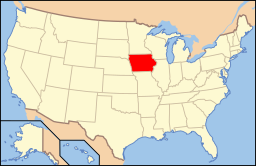
Iowas läge i USA | |
| Wikimedia Commons: Stuart, Iowa | |
| Webbplats: http://www.stuartia.com/ | |
| Redigera Wikidata | |
Stuart är en ort i Adair County och Guthrie County i delstaten Iowa, USA.
Referenser
- ^ läs online, stuartia.com , läst: 13 februari 2024.[källa från Wikidata]
- ^ United States Census Bureau, 2010 U.S. Gazetteer Files, United States Census Bureau, 2010, läst: 9 juli 2020.[källa från Wikidata]
- ^ United States Census Bureau (red.), USA:s folkräkning 2020, läs online, läst: 1 januari 2022.[källa från Wikidata]
Media som används på denna webbplats
Författare/Upphovsman: Jerry Huddleston from Hampton, Minnesota, US, Licens: CC BY 2.0
Hotel Stuart in Stuart, Iowa.
|
This is an image of a place or building that is listed on the National Register of Historic Places in the United States of America. Its reference number is 13000924. |
Författare/Upphovsman: This version: uploader
Base versions this one is derived from: originally created by en:User:Wapcaplet, Licens: CC BY 2.0
Map of USA with Iowa highlighted
Författare/Upphovsman: Arkyan, Licens: CC BY-SA 3.0
This map shows the incorporated and unincorporated areas in Guthrie County, Iowa, highlighting Stuart in red. It was created with a custom script with US Census Bureau data and modified with Inkscape.


