Stratford-upon-Avon
| Stratford-upon-Avon | |
| Stad | |
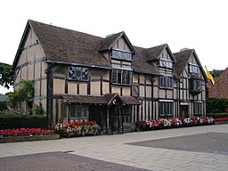
Shakespeares födelseplats i Stratford-upon-Avon | |
| Land | |
|---|---|
| Riksdel | England |
| Region | West Midlands |
| Ceremoniellt grevskap | Warwickshire |
| Administrativt grevskap | Warwickshire |
| Distrikt | Stratford-on-Avon |
| Koordinater | 52°11′34″N 01°42′23″V / 52.19278°N 1.70639°V |
| Area | 8,47 km²[1] |
| Folkmängd | 27 830 (2011)[1] |
| Befolkningstäthet | 3 286 invånare/km² |
| Tidszon | WET (UTC+0) |
| - sommartid | BST (UTC+1) |
| Postort | STRATFORD-UPON-AVON |
| Postnummer | CV37 |
| Riktnummer | 01789 |
| Geonames | 2636713 7297427 |
Contains Ordnance Survey data © Crown copyright and database right, CC BY-SA 3.0 Stratford-upon-Avons läge i Warwickshire | |
| Webbplats: www.stratford-tc.gov.uk | |
Stratford-upon-Avon (ofta enbart: Stratford) är en stad och civil parish i grevskapet Warwickshire i centrala England. Staden är huvudort i distriktet Stratford-on-Avon och ligger vid floden Avon. Tätorten (built-up area) hade 27 830 invånare vid folkräkningen år 2011.[1]
Stratford är William Shakespeares födelsestad och en byggnad som påstås vara hans födelsehus är idag museum. Staden hyser även Royal Shakespeare Companys teatrar Royal Shakespeare Theatre, Swan Theatre och The Other Place.
Historia
Staden grundades av anglosaxare och växte fram som en köpstad under medeltiden. År 1196 erhöll Stratford-upon-Avon stadsprivilegium.
Referenser
- ^ [a b c] ”Stratford-upon-Avon Built-up area - Local Area Report - Nomis”. www.nomisweb.co.uk. https://www.nomisweb.co.uk/reports/localarea?compare=E34004210. Läst 23 december 2020.
Externa länkar
 Wikimedia Commons har media som rör Stratford-upon-Avon.
Media som används på denna webbplats
Shiny red button/marker widget. Used to mark the location of something such as a tourist attraction.
Contains Ordnance Survey data © Crown copyright and database right, CC BY-SA 3.0
Map of Warwickshire, UK with the following information shown:
- Administrative borders
- Coastline, lakes and rivers
- Roads and railways
- Urban areas
Equirectangular map projection on WGS 84 datum, with N/S stretched 160%
Geographic limits:
- West: 2.10W
- East: 1.10W
- North: 52.70N
- South: 51.94N
(c) David Stowell, CC BY-SA 2.0
Stratford-upon-Avon Town Hall The current town hall was built in 1767 and replaces the previous building that was accidentally blown up during the Civil War. It is reputed to be the only Cotswold Stone building in Stratford and the statue of Shakespeare was presented by the famous actor/producer, David Garrick.
Författare/Upphovsman: Stuart Yeates [1], Licens: CC BY-SA 2.0
William Shakespeare's birthplace, Stratford-upon-Avon, Warwickshire, England.


